First full-sized 3D scan of the Titanic shipwreck captured
The high-resolution images reconstruct the 1912 wreck, revealing more about the ship’s fateful journey across the Atlantic.
Published On 17 May 2023
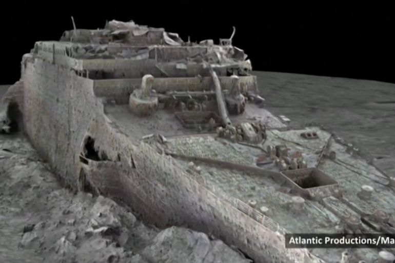
The wreck of the ill-fated Titanic ocean liner has been visualised in full for the first time as part of what researchers say is the “largest underwater scanning project in history”.
The first full-sized 3D scan of the Titanic shipwreck, published on Wednesday, may reveal more details about the ship’s fateful journey across the Atlantic more than a century ago.
Keep reading
list of 4 itemsTitanic shipyard to stay afloat
Shipyard that built the Titanic sinks into bankruptcy
100 years on: The sinking of the HMS Britannic
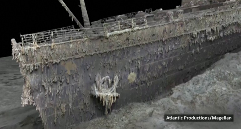
The model was created with data using deep-sea mapping gathered by two submersibles – named Romeo and Juliet – during a six-week expedition to the North Atlantic wreck site in summer 2022.
In all, the mission gathered 16TB of data from the wreckage that lies at a depth of nearly 4,000 metres (13,123 feet).
The high-resolution images, published by the BBC, reconstruct the wreck in great detail. Scientists involved in the project described it as a “game-changer”, which offers to “completely rewrite” our understanding of the disaster.
The Titanic sank in the early hours of April 15, 1912, killing an estimated 1,500 people after colliding with an iceberg on its maiden voyage from Southampton, England to New York City, the US.
The largest ocean liner of its time, the Titanic was considered a state-of-the-art ship, with watertight compartments that could be sealed if disaster struck.
Researchers say the study was conducted without interfering with the wreck and the team held a flower-laying ceremony in memory of the dead.
The shipwreck has been explored extensively since it was first discovered in 1985 approximately 650km (404 miles) off the coast of Canada, but cameras were never able to capture the ship in its entirety.
The reconstruction was carried out in 2022 by deep-sea mapping company Magellan Ltd and Atlantic Productions, who are making a documentary about the project.
Magellan’s Gerhard Seiffert, who led the planning for the expedition, told the BBC they were not allowed to touch anything “so as not to damage the wreck”.
“The other challenge is that you have to map every square centimetre – even uninteresting parts, like on the debris field you have to map mud, but you need this to fill in between all these interesting objects,” Seiffert said.
![titanic [Screengrab/Reuters]](/wp-content/uploads/2023/05/Screen-Shot-2023-05-17-at-8.15.38-PM-1684344023.jpg?w=770&resize=770%2C430)
The new scans may shed more light on what exactly happened to the liner with historians and scientists racing against time as the ship is disintegrating.
“Now we are finally getting to see Titanic without human interpretation, derived directly from evidence and data,” Parks Stephenson, who has studied the Titanic for many years, told the BBC.
Stephenson said there is “still much to learn” from the wreck, which is “essentially the last surviving eyewitness to the disaster”.
“And she has stories to tell,” he added.
Source: News Agencies