On the trail of a pirate
In Louisiana's disappearing wetlands.

Listen to this story:
The crew of Les Bons Temps (The Good Times) hoped to make it home before dark. It was early afternoon, the weather was growing colder, the radar warned of rain, and this was their second day aboard the 30-foot (nine-metre) boat, which was now spitting black exhaust over the waters of the brackish marsh. Captain Scott Maurer cut the motor.
The starboard engine was vibrating, and 45-year-old Maurer was worried. The crew tied the boat to a piling in a narrow channel of the Barataria wetlands. There wasn’t another soul in sight. In every direction, tall marsh grass swayed in the wind.
Normally, if Maurer ran into trouble near his oyster farm on Grand Isle, he’d call on another boat for help - but this waterway sees less traffic than his usual fishing grounds, and the only boats in sight were two tugs in the distance, slowly towing an enormous floating oil rig.
The crew of Les Bons Temps was on their way from New Orleans to the Gulf of Mexico, a journey of roughly 160km (100 miles). No one on board had made the trip before.
Standing at the helm in hazard-orange rain gear, Maurer worried aloud that the boat had hit something in the shallow waters, damaging a propellor.
“Could be storm debris,” he mused.
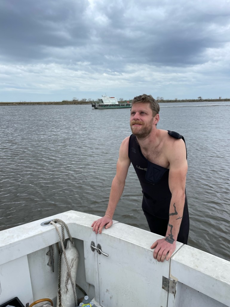
The water was an opaque brown, but 33-year-old deckhand Luke LaCava, a bright-eyed and curious Alaska fisherman who had been chain-smoking off the stern, volunteered to jump in. He put on a wetsuit, hopped off the transom, and disappeared below the surface. Without goggles, he would have to blindly grope along the propellor shaft beneath the boat.
In spring, this area would be teeming with alligators, but in January, there were none to be seen. LaCava reappeared, shivering. “Nothing,” he said.
Using his hands to make the shape of the blades in the air, Maurer gestured to check both shafts. LaCava took a deep breath and went back under.
A few seconds later, he re-emerged, gasping. “The propellor shaft has rope wrapped around it,” he said, wiping his face and spitting out sour water.
Nathan Herring, a 32-year-old Grand Isle oyster farmer, quickly fetched a knife from the boat’s galley and passed it to LaCava, who dove again once, twice, before finally emerging with a piece of black nylon crab trap line. His efforts earned him fistbumps from the crew.
With the line free, LaCava climbed aboard and Maurer fired up both engines. For a moment, he assessed their sound: better. Then Les Bons Temps was off again, heading for open water.
Gambling on The Good Times

A day earlier, Les Bons Temps had set off from New Orleans for the two-day journey to Maurer’s home on Grand Isle. It was Maurer’s first trip with the boat, a 1978 fibreglass sports yacht with two diesel engines and a few mechanical quirks.
Maurer has been an oyster farmer for 11 years. Warm and gregarious, he sports a salt-and-pepper beard since losing his razor in Hurricane Ida, the historic category-4 hurricane that ripped into Louisiana on August 29 last year, killing 95 people and leaving a trail of destruction all the way to New York.
Maurer’s oyster farm is just off the coast of Grand Isle, a sandy 17sq km (6.5sq miles) barrier island on the southern edge of Louisiana connected to the mainland by a single road. Like much of the island, it was wiped out by Ida.
With infrastructure shattered, he feared it would be near impossible to bring fresh oysters to market. Both Maurer and Herring had survived the pandemic by delivering oysters straight to New Orleans homes and restaurants, transporting thousands in a refrigeration unit in the back of their trucks. But now, roads were swamped or buried in sand, bridges were damaged, and petrol shortages made travel precarious.

Maurer had a pontoon boat, but that was only useful for working near the island’s shore, hauling and sorting oyster cages. And so, a few weeks after the storm, Maurer took a gamble and spent most of his savings on Les Bons Temps. He hoped he could use the boat to transport oysters from his farm, through the wetlands, and up to New Orleans.
But the wetlands of Louisiana - hundreds of square kilometres of saturated marsh, swamps and estuaries rich with herons, alligators, snakes and wild pigs, a vibrant and delicate ecosystem - are disappearing. So, too, are the oysters.
Fluctuating water quality, excessive heat, and freshwater diverted to prevent inland flooding kill off millions of oysters in mass mortality events. Overfishing and land loss destroy the reefs on which oysters live.
Maurer described a reef in Cocodrie, “Probably 100 yards long, where you could walk around on dry land when the tide was out, collecting oysters with buckets.” Then he added, “I can take you to that place right now and it’s under six feet of water. It’s degraded.”
A series of disasters

Grand Isle itself was once ringed in oyster reefs. Those are all gone now. The seafloor is sandy and bare and only Maurer, Herring, and two other oyster farmers still work on the island.
Thus, instead of dredging reefs, Maurer and Herring have open-water plots where they grow oysters in floating cages, a practice known as oyster aquaculture. They first raise oyster seed - baby oysters, as small as grains of sand - in “bottle nurseries,” through which they constantly circulate water. Once they’re about the size of a thumbnail, they move the oysters to cages offshore, which are tied to anchored lines and float near the water’s surface. Those cages protect the shellfish from natural predators, like drumfish and snails. This means the oysters grow more meat and less shell, and can be ready for harvest in one year instead of three.
But disappearing reefs are only one of the problems facing oyster farmers here. Ida was the latest in a series of disasters that have all but wiped them out. In the last three years alone, Maurer has had to navigate eight hurricanes, six storm evacuations, plunging water quality, and the pandemic.

Last year, as Hurricane Ida approached, Maurer put all his oyster seed inside the hatchery at Grand Isle. The seed would survive as long as it was kept cool and since the hatchery had a generator hooked up to the gas lines, the seed should have been safe there even if the power went out.
But Ida tore Grand Isle’s infrastructure to pieces, knocking out both power and natural gas. Without natural gas, the generator couldn’t run.
Maurer made it back to the island by water within a week, only to discover he’d lost almost all his seed.
"Every time we just about get to market, something happens,” he reflected. Maurer talks brightly about oysters, salinity, boats and crab pots, but when he speaks of the last years’ losses, his voice goes tight. "It used to be a huge industry. But the ocean is dying."
Going 'pirate'

Maurer was in a bind. Hurricane Ida had decimated the supply chain. The storm swept through the heart of Louisiana’s $2.4bn seafood industry, which supports one out of 70 jobs in the state, leaving him with no roads, no power, and very little seed. He decided he needed to find “new routes to market, whether by boat or by land. Go pirate on them.”
He meant this literally. As he looked for a solution among the lingering chaos of the hurricane, he thought of the notorious pirate Jean Laffite, who once operated out of Grand Isle.
In the early 19th century, the French-born pirate ran a massive smuggling operation by robbing primarily Spanish merchant vessels. The story of Laffite is well known in the region - “everybody living in or around New Orleans” has heard it, Maurer explained. There are hotels, bars, cafes, and parks all over the city named after him.

The pirate ruled Grand Isle back when it was an ideal smuggler’s paradise. His fleet prowled the waters off the Louisiana coast, captured ships at sea, and brought their cargo – cloves, coffee, cinnamon, cigars, sherry, raisins, candles and chocolate – to the island, where New Orleanians could buy it at a fraction of the normal cost. He also sold enslaved people, taking more than 500 from the ships he plundered and reselling them to the highest bidder at Grand Isle auctions.
But today, in the bayous, Laffite’s role in the slave trade is largely ignored. Instead, his band is best known for their navigation skills. The pirates would load their wares onto smaller wooden boats called “pirogues” and row, under cover of night, through the labyrinthine bayous.
Maurer decided he would follow the same route: He bought Les Bons Temps to see if he could bring his catch to town directly, bypassing the wrecked roads and bridges. In fact, the crew’s first stop would be a small town halfway between New Orleans and Grand Isle, one which is, according to a plaque in its centre, “named for the legendary privateer”: the town of Jean Lafitte.
Tracing a pirate's tracks

Maurer, Herring, and LaCava began their journey in New Orleans. As Maurer loaded the boat with supplies, he explained that they didn’t know what they would encounter along the way as Hurricane Ida had blocked and changed some waterways.
As for Les Bons Temps, he guessed based on the logs that it hadn’t been driven in more than 10 years. The gear shift had broken off so Maurer had made a makeshift replacement from a pair of vice grips. And “the clutch is kind of suspect,” he added.
“But its home port is in Grand Isle,” he said. “So, we’re bringing it home.”
Going home meant tracing Jean Laffite’s route in reverse. Laffite’s pirates chose the area because, according to author William C Davis, they could use “Louisiana’s complex and virtually unpolicable coastline” to their advantage.

Laffite’s familiarity with the deep, silent bayous, tangled swamps, and primeval forests was his greatest weapon.
According to his contemporaries, the pirate was tall and well-built with striking dark eyes and “a furious vertical crease in his brow,” and seldom smiled despite an apparently impish sense of humour.
New Orleanians seemed to like him, frustrating officials’ attempts to apprehend him. At one point, Louisiana Governor Claiborne put a $500 price on his head (about $11,000 today). Laffite responded by having his associates post broadsides around New Orleans the very next morning, promising a $1,000 reward for anyone who would deliver the governor to him in the Gulf of Mexico. They clarified, at the bottom, that he was, of course, “only jesting.”
The ghosts of past storms

But the first stage of the journey, what Maurer called the “most technical” part, was not one Laffite would have encountered. Maurer and crew set out, down the industrial canal, dredged 100 years after Laffite’s time.
The crew’s spirits were high: each of them had seen this waterway from above, waiting on raised bridges, idling in traffic as boats passed below. But to see the city from this new perspective was thrilling.
The industrial canal connects the nation’s two highest-tonnage waterways – the Mississippi River and the Gulf Intracoastal Waterway. The boat motored slowly past the ghosts of past storms: on the port side, the levee which broke during Hurricane Katrina. On the starboard side, a destroyed shipyard where bent scaffolding and aluminium still hung into the water.
At the bottom of the canal, it pulled into a lock alongside a towboat called Miss Laurie. At the prompting of the control office, the crew secured the two boats together, LaCava and Herring carefully jumping across the gap and onto the other boat’s deck. Pointing at LaCava on the deck of the Miss Laurie, Maurer joked, “Luke jumped ship already.”
The lock’s doors, topped by brown pelicans, swung shut, and the water began to rise. Maurer chatted with the captain of the Miss Laurie. Slowly, the rusted bridge ahead rose. LaCava pressed his hand to the lock’s concrete wall as the boat slid through.
Next, they followed the Miss Laurie onto the Mississippi River, the massive waterway into which about 40 percent of the continental US drains: wide, muddy, and full of treacherous currents. It would be tricky to navigate the bends in the river ahead.

Maurer motored upriver, swinging around the spit of land locals call “The End of the World;” past the six-storey abandoned US naval base scrawled with graffiti; the candy-coloured shotgun houses of the Marigny neighbourhood, where, according to Davis, Laffite once stored his contraband in the homes of friends; and the popular Riverwalk promenade where locals and tourists alike stroll.
Two hundred years ago, Jean Laffite’s brother and smuggling partner Pierre Laffite was briefly imprisoned in the royal jail, a stone’s throw from today’s Riverwalk. Pierre sat in a narrow and windowless ground-floor cell, locked in by a swing bolt, before, according to Davis’s book, The Pirates Laffite, “a person or persons unknown crept into the courtyard … and swung open the bolt,” setting Pierre free.
He released three imprisoned enslaved men, named Sam, Ceasar, and Hamilcar, from another cell on his way out before fleeing by boat back to Grand Isle. Little is known about how he escaped, but according to Rashauna Johnson, author of Slavery’s Metropolis, about unfree labour in New Orleans, the “famous 1814 jailbreak illuminated the diverse communities that formed inside the jail” as the enslaved men “either strategically allied with or became subject to a known slave trader and enemy of state to escape.” Some historians suspect the three men joined Pierre on his journey down to Barataria, where they could “join the pirate population that lived under no flag.”
'Something's gonna happen'

Les Bons Temps passed under the huge Crescent City Connection, the four-kilometre (2.5-mile) bridge spanning the Mississippi as the crew craned their necks to look up at the massive girders. The current here was powerful, and the boat chugged along slowly.
Maurer got this boat specifically, he explained, due to the diesel engines, which have more torque and can carry a heavy load - far more than the 6,000 oysters he can currently fit in his truck.

But the boat will be much more than a means of bringing oysters to market. It will be a base of operations, a floating haven with a generator and running water, a bulwark against the next hurricane.
“This allows me to be mobile in the event of a storm, water quality, power loss – I can move my whole nursery on here to safeguard next year’s crop,” he said. The next time there is a loss of power, the boat means Maurer can still run pumps, putting his nursery on the back deck and running water over the young oysters that need constant water flow. And there will be a next time. “We’re gonna get another storm,” he said as he carefully crossed the river, avoiding an enormous barge that was headed downstream. “Something’s gonna happen.”
And – like a privateer capturing prizes – Maurer also plans to use Les Bons Temps to look for wrecked boats that they can salvage, such as Herring’s sixteen-foot (five-metre) bay boat (named Paulie after his grandmother) that was lost during Ida. “At this point, I think thieves have probably gotten most of the good stuff,” Maurer reflected. “But we still might be able to salvage some things.”
'How many times can you get beat down?'

Les Bons Temps said goodbye to the Miss Laurie as it turned off the Mississippi and down the Harvey Canal. Here, the surroundings were quieter. It motored past half a dozen towboats, their red and white stacked decks like floating wedding cakes. Further down, it passed signs of a declining industry: a 20-foot (six-metre) half-sunk boat listing in the water, then a large abandoned warehouse with SOUTHERN SHELL FISH CO. on its rusted face.
Then the shipyards thinned out, and they were surrounded by forest and the occasional massive barge carrying old cars crushed into blocks. On either side, the trees, which Herring guessed were knocked down by Ida, laid on their sides, exposing their roots.
By late afternoon, they had arrived in Jean Lafitte, a town of just 1,800, populated largely by crabbers and shrimpers, and a popular launching point for swamp tours. They were the only boat to tie up for the night at a small dock near the Lafitte Fisheries Market.
Maurer’s fishing friend, Mike Roberts, pulled up in a gray Jeep. Maurer and Roberts know each other through oyster aquaculture, and their rapport largely revolves around mourning the struggles of the industry. Roberts tried oyster farming for five years but gave it up in 2020.
“We had five hurricanes that year,” he recalled. Hurricane Delta, on October 9, took his oysters and scattered them. “I spent a week and found them all. Worked my ass off. Found 370 out of 400 bags, and was just about to sell them,” Roberts said. Then, on October 28, Hurricane Zeta wiped out everything he’d recovered.
That’s when he made the decision to leave. “There wasn’t a year that I didn’t have a major mortality event. I lost 80 percent of the oysters one year.
“How many times can you get beat down? How many times can you lose that much money? Traditional oyster farmers whose families have been in the business for 100 years are out of business. I just can’t continue to take those kinds of losses.”

Roberts’ house in Jean Lafitte got seven feet (two metres) of water during Ida. Now, it’s being gutted.
He and Maurer stood on the deck, looking down into the open engine hatch as they traded stories about past storms, dead oysters, and island news.
Roberts, intimately familiar with the waterways here, would guide the crew through the next part of the trip because the bridge ahead was destroyed by Ida, replaced by a fixed bridge that boats can’t pass through. This would force the crew to take a detour, out through Bayou Perot and Bayou Rigolets, before swinging around and back into the Barataria Waterway.
The problem was that this channel is, at points, dangerously shallow. Maurer noted that another fisherman, a friend of a friend, recently hit something and destroyed their boat’s motor in Bayou Perot.
Maurer prepared to settle down in the boat’s cabin, where he’d happily spend the night in a bed tucked up by the bow, wrapped in blankets and rocked by the water. The crew drove 40 minutes north, to sleep in their respective homes in New Orleans, and plan for an early start the next day.
Displaced people and a history of racist housing policies

Early the next morning, the crew arrived back in Jean Lafitte, loaded up with coffee. They were joined by Mitchell Jarrett, 42, a friend of Herring’s who is a recreational fisherman and bird watcher.
Their next stop would be a town named Lafitte. But first they had to check supplies as Maurer warned that, depending on what they found, they might not make it to Grand Isle by dusk.
As they moved south, deeper into the Barataria wetlands, the crew would also be moving deeper into the track of Hurricane Ida’s devastation. Jean Lafitte and the surrounding towns sit outside the federal levee system, meaning they aren’t as protected from storm flooding. The areas were issued a mandatory evacuation before Ida landed, as storm surge was predicted to be “unsurvivable”.
When the storm did arrive, it brought more than ten feet (3 metres) of floodwater. Jean Lafitte Mayor Tim Kerner called it “total devastation”, adding that he’d “never seen so much water in [his] life.” An estimated 400 people had stayed in the area, either by choice or due to physical or financial obstacles.
One of those people was Keith Henry “Ike” Madison, a fisherman and long-time friend of Roberts, who has spent his whole life in Jean Lafitte. As the crew prepared Les Bons Temps to leave Jean Lafitte, Madison was eating breakfast out of a styrofoam container in a gazebo near the dock. Boxes of his possessions were neatly lined up before him. Madison, who is in his 50s, lost his home in Hurricane Ida and is currently living in the gazebo.
He’d never seen anything like Ida, he said. “When the water was to my waist,” he recalled, “I climbed in a tree. I stood in a cypress tree that I planted for my mother for about 12 hours. If I never went in that tree, I would’ve drowned.” At last, he saw neighbours out in a boat, shining lights. “I came out of the tree and I swam over there, the tide was so high.”

Madison, in several heavy layers to protect him from the cold, noted how grateful he was to have been rescued, and how beautiful Jean Lafitte was when he was a child. Maybe accustomed to the vagaries of fishing, he spoke of his situation without bitterness: after he lost his home, his only housing option was a shelter, where he felt uncomfortable. Now, he’s fighting to get any state support at all.
Madison’s home had been in his family for generations. In fact, Madison can trace his ancestors back to when they were enslaved in the area. His family first obtained their property during the Reconstruction era, when Black landowners began buying land, often in places with swampy soil, and particularly along the coast.
But it’s this very legacy that has left him houseless. Like many owners of rural, inter-generational land, Madison and his family never bothered with wills or successions. This means that he doesn’t have paperwork proving the property is his – and thus, the Federal Emergency Management Agency (FEMA), responsible for assisting those affected by federal disasters, hasn’t provided housing or support. The same issue is being faced by many Indigenous homeowners in the bayou.
Land that’s passed down informally, generation to generation, is known as heirs’ property, and is especially prevalent among rural Black landowners; it makes up more than a third of Black-owned land in the US South. The US Department of Agriculture has called heirs’ property “the leading cause of Black involuntary land loss”.
Simultaneously, communities of colour are disproportionately affected and displaced by severe weather, as centuries of racist housing policy have left them more likely to live in areas vulnerable to sea-level rise and intense heat.
'Everything's changed'

The crew of Les Bons Temps set off down the canal, passing waterside fishing camps, some of which still bore blue tarps on their storm-damaged roofs. On the starboard side, they passed the entrance to Lake Salvador. Somewhere on the opposite side of the lake, out of sight, sits a site known as The Temple, where the Laffites would sometimes sell their contraband as it commanded a view of several water routes leading from Barataria Bay to New Orleans.
As they passed the entrance to the lake, Maurer pointed at a piece of marshy land that stuck up through the water. “Everything’s changed,” he noted authoritatively, eyes still glued to the water ahead. On the sonar, the depth here read as ten feet (3 metres), but he said that, before Ida, it would probably have been closer to sixteen feet (5 metres).
Maurer called a crew meeting. Herring, LaCava, and Jarrett gathered around the helm as Maurer described the obstacles ahead: the shallow, muddy water might kick up grit, which could clog the engine. The weather forecast predicted strong winds and rain. Maurer, who has a storyteller’s tendency to digress into boating tales, recalled a time he was helping to clean up after the 2010 Deepwater Horizon oil spill, when a BP rig explosion caused the largest marine oil spill in history, and six out of 10 boats around him broke down in the choppy water.
“So that’s what could happen,” he concluded, “Or it could be completely uneventful. But you have to be prepared for the worst. And there’s a chance of things getting nautical,” he laughed.

The boat turned slowly across Bayou Perot. They were approaching more dangerous, less charted waters. Maurer kept one eye on the water and one on the sonar, while Jarrett stood next to him with a chart to warn him of obstacles.
“What are those circles?” Maurer muttered, looking at the map Jarrett had pulled up. “Is that an obstruction? Is it marking that piling?” He slowed further and watched the depth: three feet (0.9 metres), then four feet (1.2 metres), then two feet (0.6 metres).
Near the border of Bayou Perot and Bayou Rigolets, the boat’s wake had turned dark and muddy.
This is where the Laffites were crossing one night, their pirogues loaded down with cinnamon, linen, and twine they were smuggling when “suddenly in the bright moonlight, they made out the dim shapes of boats ahead of them.” The Laffites were being pursued by US troops. They threw their cargo overboard and tried to flee. Some headed into the thick swampy woods; others tried to row away. The US troops fired, killing one – and thus, this bayou is where the Laffites suffered their first fatality and were, briefly, captured.
But comparing these waterways with the pirates’ routes only highlights how much land has been lost. There are few trees to hide in, any more. Just then, the engine stuttered, and the boat lurched.
Maurer slowed down. “We hit something?” He asked the crew, alarmed. Herring and LaCava were on their feet, looking over the stern. On the GPS and Google Maps, it said the boat was on top of land, though there was water in every direction, and the sonar hovered around 0.6 metres (two feet).
LaCava and Herring didn’t see anything in the water. The boat chugged on.
A football field every 48 minutes

Roberts appeared ahead, pulling up in what Maurer called “the Cadillac of crab boats”: his grandson’s boxy 25-foot (7.6 metre) Carolina Skiff, rigged up with crab traps on its roof. He had come to lead Les Bons Temps to safe harbour.
Maurer steered behind Roberts, following his trail closely to avoid any more obstacles. When Roberts was a child, he said, this was land bearing marsh grass and small ponds.
“Probably the first time I was able to squeeze through there with a boat was 35 years ago,” he recalled. “A shallow water motorboat. Now, it’s all open water.”
It is reflective of just how quickly the land is sinking here, and how each hurricane has accelerated that change. Louisiana faces the highest rate of sea-level rise on the planet. The state has already lost a dizzying 5,000sq km (1,930sq miles) of land in the last 90 years. Most of southeastern Louisiana not protected by levees will be gone within 50 years. The rate of land loss is stark: Louisiana loses, on average, roughly a football field worth of land every 48 minutes.

Oyster reefs can mitigate some of this land loss. Oysters are a keystone species, meaning they are crucial to holding their entire ecosystem together. The reefs also anchor sediment and diffuse the erosive power of waves.
But oysters are disappearing, not just in Grand Isle but everywhere: a recent report in BioScience warned that coastal degradation and resource extraction “have pushed oyster reefs to the brink of functional extinction worldwide.” The report estimates that, globally, 85 percent of oyster reefs have been lost.
When a reef is gone, leaving bare sand behind, oysters can’t grow because there’s nothing for their young to attach to. But Maurer pointed out a strange bright spot: all this debris, the bent and submerged wreckage, is, ironically, providing new surfaces on which oysters can flourish.
Treacherous waters

By lunchtime, Roberts had guided Les Bons Temps back into the main waterway and they all tied up at a dock in Lafitte. They circled up to decide their next move. Behind them were the remains of a hardware store wrecked by Ida, now just stacks of blue drawers spilling loose nails. On the radar, a light storm was blowing in. Roberts advised the crew to wait and finish the trip the next day, but the crew of Les Bons Temps decided to press on.
Soon, they were in Lafitte territory. A thin rain started to fall. The boat rocked in one-metre (three-foot) swells, and the crew grabbed on to the railings to steady themselves. The occasional bottleneck dolphin swam alongside the boat, dipping slowly in and out of the wake. “This is their home,” Maurer said, spotting the spray of another pod in the distance. They are so deep in the bay because Hurricane Ida pushed saltwater further north, he explained.
The dolphins crossed ahead of the boat as it approached Bayou St Denis. And here, again, was proof of how the landscape has shifted since the pirates’ time: Pierre Laffite once prepared for a fight with the British military by blocking this waterway with felled trees. Today, the only trees around are the gray and skeletal remains of cypress killed by saltwater encroachment and the open water stretches 100 metres (328 feet) across, too far to be blocked by trees.
Likewise, a few miles east is the site of former Cat Island, once used by the Lafittes to run boats aground. Until very recently, its five acres (two hectares) and tall mangroves served as the fourth-largest bird rookery in Louisiana. But after the Deepwater Horizon oil spill, the mangroves died. Today, the island is completely gone.
At last, Maurer sighted a dot on the horizon. It was the Grand Isle water tower that stands near his house.
“Land, ho,” he joked from the deck.

Maurer motored towards home, passing several other sunken and stranded boats listing against a rock jetty. Today, with a population of just 1,000, the island is still a good place for outlaws and entrepreneurs. Maurer told the story of one of his neighbours, Badon, who, long ago, visited a water-bound graveyard in Hackberry Bay, dug up two human skulls, and then tried to trade them at a bar in exchange for alcohol. Badon was 12.
Maurer parked the boat next to his house, a two-room trailer on three-metre (10-foot) stilts overlooking a small harbour. The surrounding blocks still bear huge piles of debris, the detritus of houses destroyed by Ida. Some lots were simply empty, the houses gone - Roberts noted the similarity to all the greenspace left after Hurricane Katrina; on Grand Isle, Ida had left “sandspace.” The crew unloaded equipment, stepping over oyster cages, some of which still contained Herring’s dead catch, choked by Ida’s mud and silt. On Maurer’s balcony, they opened a bottle of champagne as they looked down at the boat they’d brought home.
They may not have boarded schooners or smuggled guns, but Maurer and his crew were navigating treacherous waters to bring the people of New Orleans the goods that they want. That may just make them pirates after all.