A tiger roars in the Bay of Bengal
A tropical cyclone is expected to bring life-threatening weather to Bangladesh and Myanmar.
Published On 14 May 2013
Residents of Bangladesh and Myanmar are preparing for the arrival of what could be a deadly tropical storm, heading through the Bay of Bengal.
Tropical Cyclone Mahasen, currently lying approximately 600km east of Chennai, is expected to make landfall in eastern Bangladesh.
Keep reading
list of 4 itemsCould shipping containers be the answer to Ghana’s housing crisis?
Thousands protest against over-tourism in Spain’s Canary Islands
Holding Up the Sky: Saving the Indigenous Yanomami tribe in Brazil’s Amazon
Latest predictions suggest Mahasen will arrive onshore in Chittagong just before 06 GMT on Friday, but its impact is also likely to be felt in the coastal region of neighbouring Myanmar.
Mahasen is expected to strengthen to the equivalent of a category 1 Atlantic hurricane, with peak sustained winds of 130kph and gusts as 155kph.
Shipping across the region has already been warned of the impending arrival of the storm and many vessels are either returning to port, or remaining there, until Mahasen has passed.
Parts of Bangladesh has already experienced two thirds of a typical May’s rainfall in the first 10 days of the month, so news of a total of 200 to 500mm of additional rain will not be welcome.
The greatest threat to life may not come directly from the wind or the rain, but from a storm surge which is anticipated to be in the order of one to 1.5 metres. With much of this region at or below sea level, any surge can penetrate well inland, giving people little or no chance of escape.
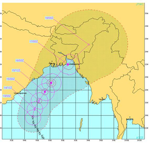 |
| Tropical Cyclone Mahasen [Joint Typhoon Warning Center] |
The impact of Mahasen could be disproportionately large as recent disturbances between Buddists and Muslims have forced 130,000 people to flee their homes, with half now living in tented camps in low-lying areas next to the coast.
Tropical cyclones in the Bay of Bengal exhibit a peak during the May-June period. This particular storm has been linked to an active phase of the Madden Julian Oscillation (MJO) that has been moving through the Indian Ocean over the last week.
The MJO is a link between the atmosphere and tropical convective storm clouds. This area of enhanced activity appears to travel through the atmosphere at speeds of 14 to 30kph, and is most noticeable through the Indian and Pacific Oceans.
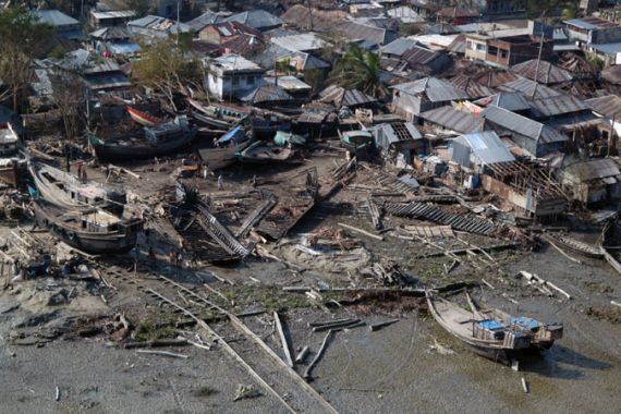
As recently as 2008, a severe storm, Nargis, led to the worst natural disaster in Myanmar’s history. When Nargis made landfall on May 2, the storm surge through the Irrawady delta killed 138,000 people.
Another cyclone hit Bangladesh on the night of April 2 1991, striking Chittagong with winds of 250kph. A storm surge of six metres swept inland, killing at least 138,000 people, leaving another 10 million homeless, and causing $1.7 billion worth of damage.
There is no suggestion that Mahasen will be anywhere near as deadly as either of these two storms, but these examples illustrate how vulnerable countries bordering the Bay of Bengal are, and why authorities are desperately evacuating as many people as possible.
‘We’re definitely very concerned,’ said Vivian Tan, a spokeswoman for the United Nations refugee agency. ‘We are working around the clock, trying to get as many people out of low-lying areas and into decent shelters.’
Worryingly, the computer forecasts appear to be in broad agreement as to the potential track and intensity of Mahasen in the coming days.
Source: Al Jazeera