A March blizzard in bloom
A winter storm is promising to bring destructive weather to almost half of the US.
Published On 5 Mar 2013
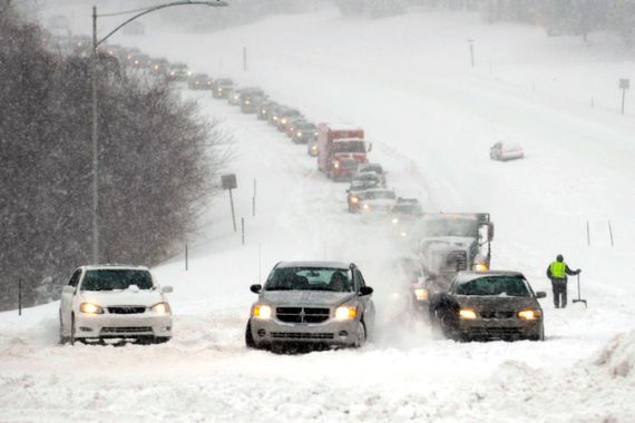
They’re called “Alberta Clippers” in the world of meteorology and to people who experience them the most. These are fast moving snow storms that originate out of the Canadian province of Alberta and then rapidly move through the northern US tier.
For North Dakota this is considered a normal late winter storm. We’re talking about the high winds, deep drifting snow and low visibility now being seen across the state.
Keep reading
list of 4 itemsAfter the Hurricane
World’s coral reefs face global bleaching crisis
Why is Germany maintaining economic ties with China?
The transportation department is being extremely cautious for the state and has recommended “no travel” on the roads from Monday evening through Tuesday. Whiteout conditions have dropped the visibility down to almost nothing, making driving extremely dangerous.
Air travel has already been affected for the international hub of Minneapolis. On Monday there were 107 flight cancellations and more are expected on Tuesday as well as for Chicago and Indianapolis.
Wednesday is also expected to be a noteworthy day. The “clipper” is forecasted to strengthen as it continues to move toward the eastern seaboard. Rain will turn to snow for major cities such as Washington, Philadelphia and Newark.
The amount of snow is going to depend on the exact path that the low will take as it exits the east coast. If it moves slightly to the north, then Washington could receive as low as 18cm of snow. But if the storm tracks a little more to the south, then that amount could be as high as 40cm.
Unfortunately this is not the only concern from our late winter event. On Thursday a storm surge is expected to be over a metre high along the Maryland and Delaware coasts. The circulation of the storm as it moves into the Atlantic will push the seas toward the coast. These areas are still highly susceptible due to the damage they received from Superstorm Sandy last October.
Source: Al Jazeera