Preparing for landfall
Tropical Cyclone Giovanna continues to strengthen as it sets its sights on Madagascar

Published On 13 Feb 2012
 |
|
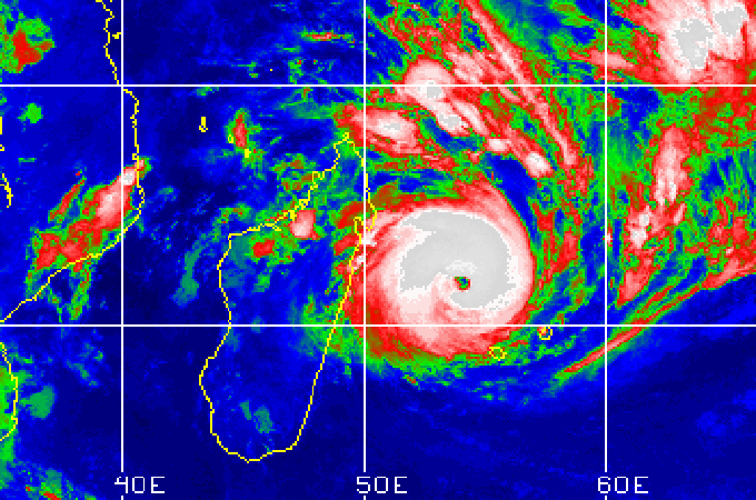
An enhanced look at Tropical Cyclone Giovanna shows its well defined eye from space [EURMETSAT] |
Over the last 24 hours, Tropical Cyclone Giovanna has strengthened more than previously expected. With current winds well over 200 kilometres per hour, the storm’s current intensity would be equivalent to that of a category four hurricane if it was in the Atlantic basin.
Even with the well defined eye of the storm still over 300 kilometres to the east, the outer rain bands have already brought heavy intermittent showers for the northeast regions of Atsinanana and Analanjirofo.
Keep reading
list of 4 itemsPalestinian Prisoner’s Day: How many are still in Israeli detention?
‘Mama we’re dying’: Only able to hear her kids in Gaza in their final days
Europe pledges to boost aid to Sudan on unwelcome war anniversary
Over the next 12 to 18 hours, while Giovanna remains over the warm waters of the South Indian Ocean, it is expected to further strengthen before making an overnight landfall.
Residents along the lower lying eastern seaboard have been urged to evacuate to higher ground. Despite the fact that Cyclone Giovanna expected to make a landfall during lower tides, it is still expected that the coastal region could see over a one and a half metres storm surge. Power and water outages, structural wind damage as well as inland flooding can be expected.
Early Tuesday morning, the storm will begin to track more to the southwest, following a path that takes the storm just south of the capital of Antananarivo. The higher elevations of the central portion of the country will help to weaken the system rapidly, but also help to funnel the heavy rain through the river valleys and instigate flash flooding.
Once this storm pushes over Madagascar, it will emerge into the Mozambique Channel, where it could regain intensity. Residents in southern Mozambique need to monitor this situation closely as this region has already seen flooding this year from two previous cyclones.
Source: Al Jazeera