US Gulf coast braces as Beta set to strengthen into hurricane
The storm comes amid an exceptionally busy hurricane season that scientists say is due, in part, to climate change.
Published On 19 Sep 2020
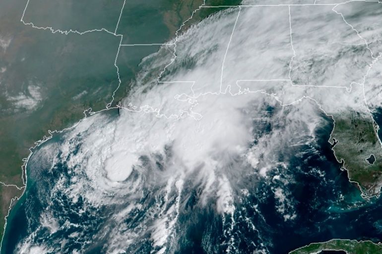
Texas is the latest place in the United States bracing for a storm during this year’s exceptionally busy storm season, as Tropical Storm Beta is expected to strengthen into a hurricane before making landfall later this week.
Both the city of Galveston and Galveston County on Saturday issued voluntary evacuation orders ahead of Beta’s expected arrival, as did the city of Seabrook to the north of Galveston.
Keep reading
list of 4 itemsPhotos: Heavy rains, lightning in Pakistan kill at least 50 people
Inside the pressures facing Quebec’s billion-dollar maple syrup industry
Coral reefs around the world experiencing mass bleaching, scientists say
Galveston’s interim mayor, Craig Brown, said in a statement that high tides and up to 25cm (10 inches) of expected rainfall would leave roads impassable, especially along the city’s west end and low-lying areas.
Meanwhile, County Judge Mark Henry said during a Saturday news conference that he was concerned that rising waters could create a storm surge, but that a mandatory evacuation order is not expected.
“If you can survive in your home for three or four days without power and electricity, which we’re not even sure that’s going to happen, you’re OK,” Henry said. “If it’s uncomfortable or you need life support equipment, maybe go somewhere else.”
Beta strengthening
On Saturday, Tropical Storm Beta was strengthening in the Gulf of Mexico, 495km (307 miles) east-southeast of Corpus Christi, Texas, and 395km (245 miles) south of Lake Charles, Louisiana, the US National Hurricane Center said in an advisory.
The storm was forecast to become a hurricane on Sunday and triggered a tropical storm warning from Port Aransas, Texas, to Intracoastal City, Louisiana.
In Lake Charles, Louisiana, where thousands of people remain without power more than three weeks after Hurricane Laura slammed into the coast, there were concerns that Beta could hit the area with rain once again.
As Tropical Storm Beta approaches the TX coast, it brings the threat of heavy rain and flash flooding. On its current forecast track, the greatest threat stretches from the Middle TX Coast into southwest LA. Any change in the track could result in the threat area changing too. pic.twitter.com/S1jEKfQcrM
— NWS Weather Prediction Center (@NWSWPC) September 19, 2020
Up to 51cm (20 inches) of rain was considered possible in some parts of the area, Donald Jones, a National Weather Service meteorologist based in Lake Charles, said in a Saturday briefing.
“A lot of people have been saying, ‘Is this going to be like Harvey? Is this going to be like Imelda?'” Jones said, referring to previous storms. “We’re not talking about rainfall totals yet that are on the orders of magnitude that we saw with that.”
Forecasters were predicting up to 1.2m (4 feet) of storm surge along parts of the Texas coast that included Baffin Bay, Corpus Christi Bay and Galveston Bay.
|
|
Wind, heavy rainfall and life-threatening surf and rip current conditions were also expected with the storm.
Underscoring the exceptionally busy storm season, forecasters ran out of traditional storm names on Friday, forcing the use of the Greek alphabet for only the second time since the 1950s.
Meanwhile, Hurricane Teddy, which was centred 828km/h (515mph) southeast of Bermuda on Saturday, remained a powerful storm, with maximum sustained winds at 193km/h (120mph) and moving northwest at 22km/h (14mp).
A tropical storm warning was in effect for Bermuda, while large swells from Teddy were expected to impact the Lesser Antilles, the Greater Antilles, the Bahamas and Bermuda, as well as the US East Coast.
Source: News Agencies