UK and Ireland battered by strong winds and torrential rain
The remnants of Hurricane Pablo helped strengthen a North Atlantic storm.
Published On 3 Nov 2019
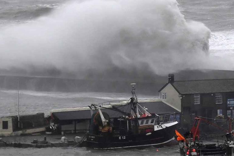
High winds and heavy rains from an extremely strong weather system that moved in from the Atlantic has battered much of the United Kingdom and Ireland.
This storm, that got some of its energy from the remnants of Hurricane Pablo, brought destructive winds to much of southwestern England on Saturday morning.
Keep reading
list of 4 itemsAfter the Hurricane
World’s coral reefs face global bleaching crisis
Why is Germany maintaining economic ties with China?
The port city of Plymouth, located on the southwestern coast of England, received a peak gust of 133 kilometres (83 miles) per hour, while just down the coast the winds at Royal Naval Air Station at Culdrose hit 132km/h (82 miles/h).
The winds and rain also caused problems for travellers – at London Heathrow Airport on Saturday, 265 flights were delayed.
Thousands of people in parts of Cornwall and North Devon were also left without electricity after trees fell on power lines.
Meanwhile, train services were discontinued between Newquay and Par when the ground below the tracks became unstable due to the heavy rain.
The UK met office had issued yellow warnings for wind and rain through Saturday evening for parts of Wales and England.
On Sunday, the storm’s fury began pounding France with even stronger winds. In Cap Ferret, just off the coast of Bordeaux, a wind gust topped out at 162km/h (101 miles/h), equivalent to a category 2 hurricane.
The strong winds will continue moving east into the Mediterranean Sea and then across parts of Italy early on Monday morning.
Heavy rain will also accompany these winds on Monday with accumulations well over 100mm. The risk for localised flash flooding will be a high concern between Rome and Naples.
The flood threat will then shift across the Adriatic Sea into Montenegro on Tuesday.
Source: Al Jazeera, News Agencies