Hurricane Dorian: Catastrophic storm slams the Bahamas
Second-strongest Atlantic storm on record expected to continue to pound the Bahamas before moving northwest towards US.
Published On 2 Sep 2019
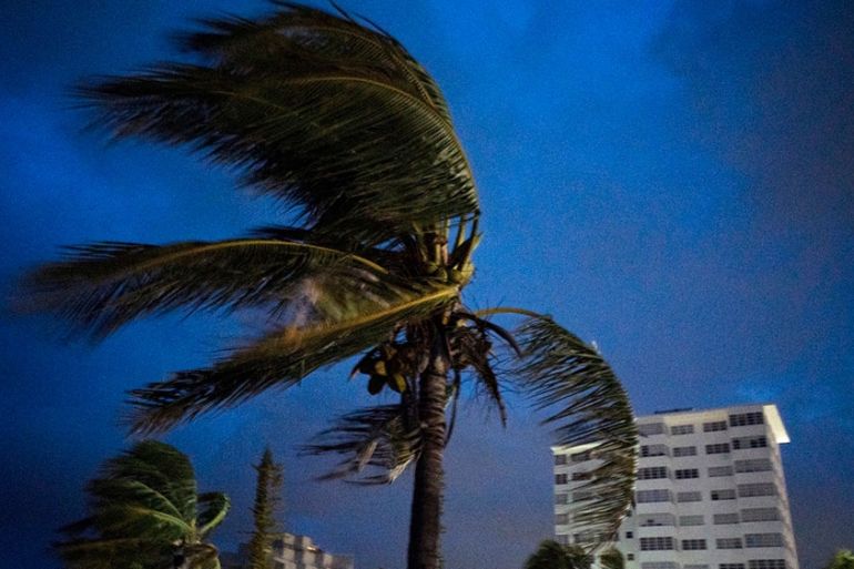
In a slow, relentless advance, a catastrophic Hurricane Dorian kept pounding the northern Bahamas early on Monday, as one of the strongest Atlantic storms ever recorded left wrecked homes, shredded roofs, tumbled cars and toppled power poles in its wake.
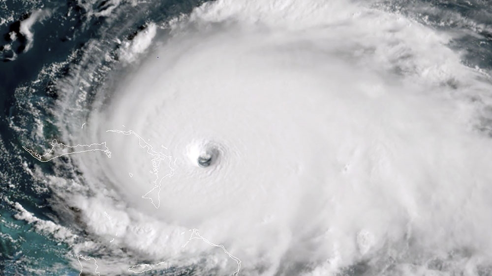
The storm was stalled over Grand Bahama Island, packing maximum sustained winds of 249 kilometres per hour (155 mph) and moving at 2 km/h, the Miami-based National Hurricane Center (NHC) said in an advisory at 11am (16:00 GMT). Dorian was expected to pound Grand Bahama for much of the day.
Keep reading
list of 4 itemsPhotos: Dubai reels from flood chaos as record rains lash UAE
Dubai submerged in floods as UAE gets over a year’s worth of rain in hours
Heavy rains kill 18 in Oman as flash floods lash UAE
Information began emerging from the affected islands, with Bahamas Power and Light saying there is a total blackout in New Providence, the archipelago’s most populous island.
“The reports out of Abaco (island) as everyone knows,” company spokesman Quincy Parker told ZNS Bahamas radio station, “were not good.”
There were no immediate estimates of casualties.
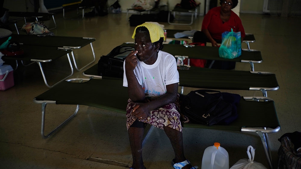
Most people went to shelters as Dorian, then a Category 5 storm, approached, with tourist hotels shutting down and residents boarding up their homes. But many people were expected to be left homeless.
“It’s devastating,” Joy Jibrilu, director general of the Bahamas Ministry of Tourism and Aviation, said on Sunday afternoon. “There has been huge damage to property and infrastructure. Luckily, no loss of life reported.”
On Sunday, Dorian’s maximum sustained winds reached 297 km/h (185 mph), with gusts up to 354 km/h (220 mph), tying the record for the most powerful Atlantic hurricane to ever make landfall. That equalled the Labor Day hurricane of 1935, before storms were named. The only recorded storm that was more powerful was Hurricane Allen in 1980, with 305 km/h (190 mph) winds, though it did not make landfall at that strength.
Don Cornish, the disaster manager for the northernmost island Grand Bahama, said it sounded like a “freight train is passing”.
“We’re getting a lot of frantic people calling in about flooding issues,” he told NPR on Monday morning.
Forecasters said Dorian was most likely to begin pulling away from the Bahamas early on Tuesday and curving to the northeast parallel to the US Southeast seaboard. Still, the potent storm was expected to stay close to shore and hammer the coast with dangerous winds and heavy surf, while authorities cautioned that it could still make landfall.
According to a Monday morning advisory from the US National Hurricane Center in Miami, the storm was virtually parked over Grand Bahama island, which was in for a “prolonged period of catastrophic winds and storm surge” though the night. It also said Florida’s east-central coast may see a brief tornado sometime between Monday afternoon and Monday night.
Mandatory evacuations on US coast
South Carolina Governor Henry McMaster issued an order on Sunday for the mandatory evacuation of his state’s entire coast. The order, which covers about 830,000 people, was to take effect at noon on Monday, at which point state troopers were to make all lanes on major coastal highways one-way heading inland.
“We can’t make everybody happy, but we believe we can keep everyone alive,” McMaster said.
A few hours later, Georgia’s Governor Brian Kemp ordered mandatory evacuations for that state’s Atlantic coast, also starting at midday on Monday.
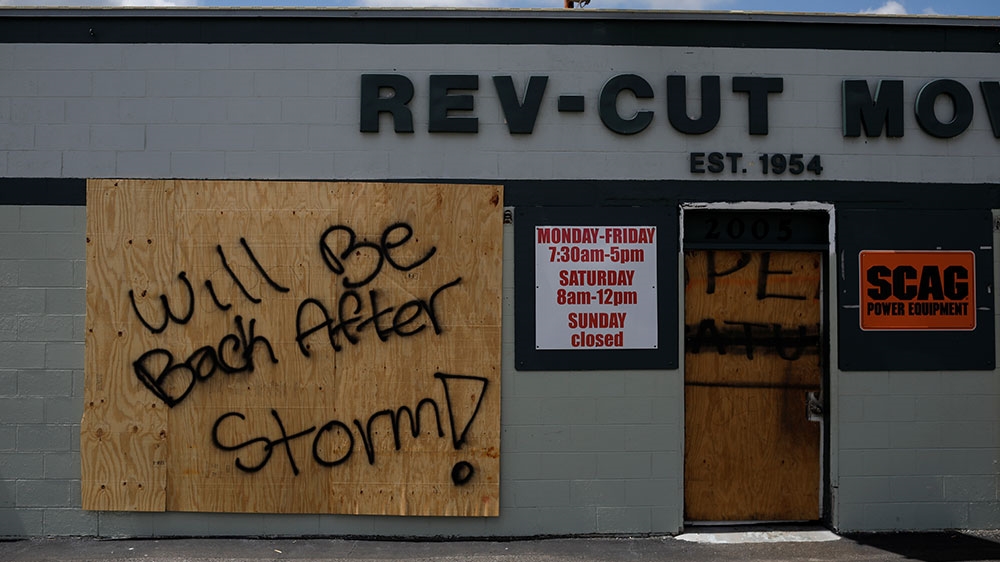
Authorities in Florida ordered mandatory evacuations in some vulnerable coastal areas. North Carolina Governor Roy Cooper warned his state that it could see heavy rain, winds and floods later in the week.
‘Catastrophic conditions’
Dorian first came ashore on Sunday at Elbow Cay in Great Abaco Island at 12:40pm (16:40 GMT), then made a second landfall near Marsh Harbour at 2pm (18:00 GMT).
“Catastrophic conditions” were reported in Abaco, with a storm surge of 5.5-7 metres (18 to 23 feet).
Video that Jibrilu and government spokesman Kevin Harris said was sent by Abaco residents showed homes missing parts of roofs, electric lines on the ground and smashed and overturned cars. One showed floodwaters rushing through the streets of an unidentified town at nearly the height of a car roof.
In some parts of Abaco, “you cannot tell the difference as to the beginning of the street versus where the ocean begins,” Prime Minister Hubert Minnis said. According to the Nassau Guardian, he called it “probably the most sad and worst day of my life to address the Bahamian people.”
Bahamas radio station ZNS Bahamas reported that a mother and child on Grand Bahama had called to say they were sheltering in a closet and seeking help from police.
Silbert Mills, owner of the Bahamas Christian Network, said trees and power lines were torn down in Abaco.
“The winds are howling like we’ve never, ever experienced before,” said Mills, who was riding out the hurricane with his family in the concrete home he built 41 years ago on central Abaco.
The Bahamas archipelago is no stranger to hurricanes. Homes are required to have metal reinforcements for roof beams to withstand winds into the upper limits of a Category 4 hurricane, and compliance is generally tight for those who can afford it. Risks are higher in poorer neighbourhoods, with wooden homes in low-lying areas.
On Tuesday and Wednesday, Dorian is forecast to be 64 to 80km (40 to 50 miles) off Florida, with hurricane-force wind speeds extending about 56km (35 miles) to the west.
The US National Hurricane Center issued a hurricane watch for Florida’s East Coast from Deerfield Beach north to the Georgia state line. The same area was put under a storm surge watch. Lake Okeechobee was under a tropical storm watch.
Ken Graham, director of the hurricane centre, urged people not to bet on safety just because the forecast track had the storm a bit offshore. With every new forecast, “we keep nudging (Dorian’s track) a little bit to the left” – that is, is closer to the Florida coast, Graham said.
US President Donald Trump already declared a state of emergency and was briefed about what he called a “monstrous” storm.
“We don’t know where it’s going to hit but we have an idea, probably a little bit different than the original course,” Trump said. “But it can change its course again and it can go back more toward Florida.”
Source: Al Jazeera, News Agencies