Tasmania braces for back-to-back storms
Residents advised to prepare for damaging winds, heavy rain, snow and flooding as two major storms set to hit island.
Published On 20 Aug 2019
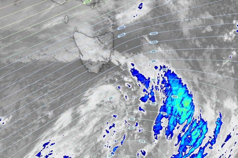
Tasmania is bracing for damaging winds, heavy rain, snow and flooding as two storms are set to push through the island state today and tomorrow.
In an alert issued just before noon local time on Tuesday, the State Emergency Service (SES) said that conditions would deteriorate later in the day and through Wednesday.
Keep reading
list of 4 itemsAsia bears biggest climate-change brunt amid extreme weather: WMO
Photos: Highest-level rainstorm warning issued in south China’s Guangdong
Europe endured record number of ‘extreme heat stress’ days in 2023
One storm in the southern end of the Tasman Sea will usher in two separate but very strong cold fronts.
The first front began moving through Tasmania on Tuesday evening, with winds of up to 75 kilometres per hour. Higher elevations across the island were picking up substantially higher gusts with Maatsuyker Island seeing a peak gust of 147km/h and Kunanyi/Mount Wellington recording 139km/h.
Residents across the island have been asked to tie down and secure any loose items, including outdoor furniture and play equipment. Widespread downed trees and powers lines were expected.
Heavy rain and flooding will also accompany these storms and it is the southwest that could see significant river rises. The 70 millimetres expected will funnel down from the higher elevations into valleys and streams. Farmers have been advised to consider moving livestock to higher ground.
The second front is expected to push through on Wednesday again with strong winds, heavy rain and much colder air.
Snow is predicted to fall as low as 400 metres on Wednesday afternoon.
Waves along the south-west coast are expected to reach heights of seven to eight metres.
The SES advises that residents should check in on family and neighbours during the storm and be prepared for the expected power outages.
Source: News Agencies