Hurricane Rosa to bring flash floods to Mexico, US
It has been an above average tropical season for the eastern Pacific.
Published On 29 Sep 2018
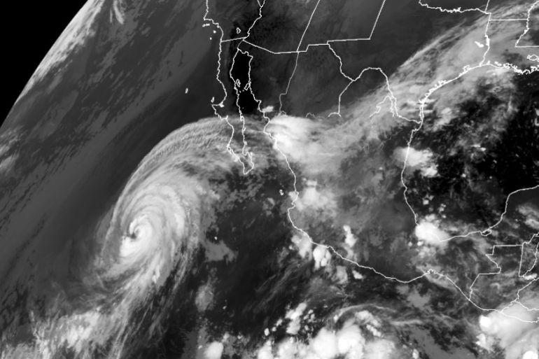
Hurricane Rosa, currently in the eastern Pacific, has put Mexico and southwestern US on alert for the risk of flash flooding.
Once a strong Category 4 storm, Rosa continues to weaken as it moves to the north-northeast, making a projected landfall in the Mexican state of Baja California on Monday afternoon.
Keep reading
list of 4 itemsPhotos: Deadly floods wreak havoc in Kenya’s capital
China evacuates over 100,000 as heavy rain continues to lash south
Asia bears biggest climate-change brunt amid extreme weather: WMO
Baja California Sur is already seeing the higher clouds moving in from Rosa, which is approximately 900km away.
Over the next 24 to 48 hours, Sinaloa, Nayarit and Jalisco states will see stronger winds and increased coastal storm surge.
Rosa is expected to bring 100 to 400mm of rain as it passes over the Baja Peninsula as a tropical storm leading to the increased risk of flash flooding and mudslides for this arid state.
Even though Rosa is expected to weaken considerably as it passes across Baja California, much of the moisture will continue to push into the southwestern US through midweek.
Arizona, California and Nevada have already issued flash flood watches before the expected rainfall – 50 to 100mm of rain could fall in a very short period of time.
Some forecast models are suggesting the storm’s moisture will be picked up by a system coming out of the Pacific Northwest and help enhance the rainfall totals across the Midwest this coming week.
This year, the eastern Pacific has been particularly active with 17 named storms and 10 hurricanes.
In an average season, there are normally 15 named storms and eight hurricanes.
With the end of hurricane season still weeks away, the final total of eastern Pacific storms could easily go up.
Source: Al Jazeera, News Agencies