Google unveils detailed North Korea map
Highly detailed map produced by “community of citizen cartographers” working for several years.
Published On 29 Jan 2013
Google’s Maps service has unveiled a highly detailed map of North Korea, an area that went largely undocumented on the service previously.
Monday’s development comes just weeks after Eric Schmidt, chairman of the California-based-based internet company, embarked on a secret trip to the country.
Keep reading
list of 4 itemsCould shipping containers be the answer to Ghana’s housing crisis?
Are Chinese electric vehicles taking over the world?
First pig kidney in a human: Is this the future of transplants?
“For a long time, one of the largest places with limited map data has been North Korea. But today we are changing that,” Jayanth Mysore, a senior product manager at Google Map Maker, said in blog posting on Monday.
Map Maker creates maps from data that is provided by the public and fact-checked in a similar process to that used by Wikipedia.
Mysore said the North Korea section had been completed with the help of a “community of citizen cartographers” working over a period of several years.
“While many people around the globe are fascinated with North Korea, these maps are especially important for the citizens of South Korea who have ancestral connections or still have family living there,” he said.
| |
|
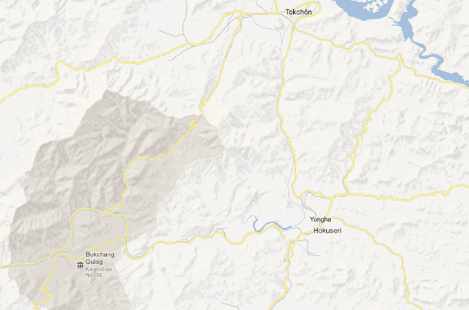
The maps show ‘re-education centres’ [Google] |
South Korean officials on Tuesday welcomed the Google map initiative.
“We think that this could be an opportunity for the world to know more about North Korea and an opportunity for the North to open itself more,” a unification ministry spokeswoman said.
The North has a domestic intranet, which is cut off from the rest of the world – allowing its very limited number of users to exchange state-approved information and little more.
Access to the full-blown internet is limited to a few hundred, maybe 1,000 people at most, experts estimate.
Schmidt said he had told officials in the North that the country would never develop unless it embraced internet freedom.
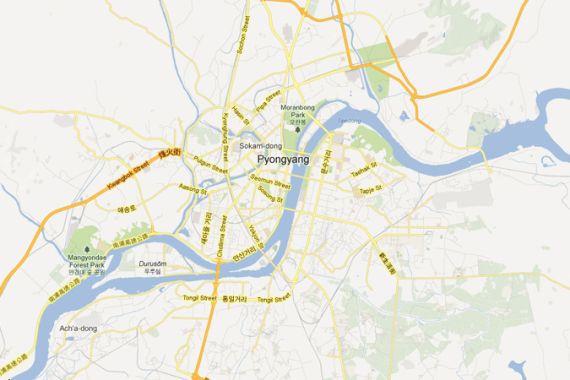
The new Google map offers a detailed map of the capital Pyongyang, showing hospitals, subway stops and schools.
Outside the capital, the detail is sparse, but noticeable on an overview of the country are a series of city-sized, grey-coloured areas which, when zoomed in on, are identified as “re-education camps”.
As many as 200,000 people are estimated to be held in the North’s detention system.
Google has helped cast a light on the location of these camps before, through its popular Google Earth satellite imagery service.
Groups and individuals involved with human-rights research on North Korea have used the satellite pictures to confirm the location of known camps and uncover the existence of new ones.
Source: News Agencies