Sandy – remarkable in so many ways
Aside from the devastation it brought to the northeastern US, Sandy will be remembered for the many records it broke.
Published On 1 Nov 2012
 A yacht is washed up on Staten Island. [Reuters]
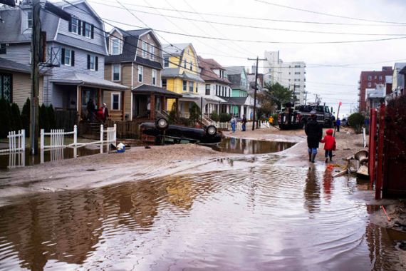
The devastation wrought by Sandy to New York and New Jersey illustrates just how unique this storm was. In many ways, it was the worst storm to hit the city since it was founded in 1625.
Here are some facts and statistics about Sandy which made it an unforgettable experience for so many people:
Keep reading
list of 4 itemsTurtles swimming to extinction in Malaysia as male hatchlings feel heat
Could shipping containers be the answer to Ghana’s housing crisis?
Thousands protest against over-tourism in Spain’s Canary Islands
1. Size: Sandy developed into a storm of epic proportions. A typical hurricane has a diameter of 650km. But Sandy developed into such a monster storm that tropical storm-force winds extended some 780km in all directions.
2. Track: Most hurricanes, after exiting the Caribbean turn towards the east into the Atlantic. Sandy was driven westwards across the northern portion of the eastern seaboard by an area of high pressure in the North Atlantic.
3. Power: Any hurricanes which take a similar path to Sandy are weakened by a combination of cooling seas and unfavourable winds in the upper atmosphere. Sandy fed off near-record water temperatures along the eastern seaboard and then turned into a ‘superstorm’ as it engaged with a cold weather system driving in from Canada. These two factors morphed Sandy into a hybrid storm – a post-tropical cyclone of epic proportions.
4. Winds: Unprecedented winds were recorded along the New York/New Jersey shoreline. A gust of 151kph struck Eaton’s Neck on Long Island and similar gusts were reported in many locations.
5. Waves and surge: Massive waves and a surge, produced by strong winds piling up the water, made flooding across the coastline inevitable. What made the situation far worse was that Sandy’s arrival coincided with the full moon resulting in high spring tides.
The storm surge measured 4.23 metres at The Battery at the southern tip of Manhattan Island. This exceeded the previous record of 3 metres set back in 1960 during Hurricane Donna.
Wave heights in Long Island Sound reached an astonishing 9.9 metres exceeding the previous peak of 7.9 metres during 2011’s Hurricane Irene.
6. Precipitation: Precipitation from Sandy was extreme. On the western edge of the storm accumulations of snow totaled nearly a metre in parts of West Virginia and Maryland. Rainfall accumulations were up to 300mm – three times the average rainfall for October.
7. Pressure: Sandy produced the lowest mean sea level pressure ever recorded north of Cape Hatteras, at 943mb. Pressure records were broken across Pennsylvania, Maryland and New Jersey.
Even though climate change raises the possibility of more severe storm systems in the coming years, it is highly probable that ‘superstorm’ Sandy will retain many of its records for decades, if not centuries, to come.
Source: Al Jazeera