Typhoon update
An update on the progress of tropical storms affecting the Philippines and China
Published On 29 Sep 2011
 |
| Typhoon Nesat |
There will be little time for any kind of clear-up operation in the Philippines over the next couple of days. Typhoon Nesat may have come and gone but hot on its heels is the next system in the form of Typhoon Nalgae.
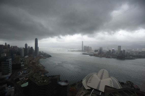
Lets deal with Nesat first though. At its worst, it produced around 240mm of rain in a 24 hour period on its passage across the Philippines, leaving at least 21 people dead. It is now in the process of running across southwest China (having hit Hainan around 1200GMT on Thursday). As previously stated this is a massive storm and the outer bands have already caused flooding across a good part of southern China. Even Hong Kong has suffered some wind damage and flooding as the storm moved through the South China Seas. Even the financial markets were forced to close for a time.
Keep reading
list of 4 itemsAsia bears biggest climate-change brunt amid extreme weather: WMO
Photos: Highest-level rainstorm warning issued in south China’s Guangdong
Europe endured record number of ‘extreme heat stress’ days in 2023
Nesat is now in the process of heading towards Hanoi, and is expected to reach the northwest of Vietnam on Friday evening. By this stage it is no longer expected to be a typhoon but the winds are not as big a concern as the rain because of course, the storm is moving towards an area where the ground is already saturated. Heavy rain and heavy seas will make matters worse here in the coming days.
Meanwhile our next system, Typhoon Nalgae is strengthening as it heads towards Luzon. It is following a similar track but it is not as big as Nesat. Nevertheless it will inevitably exacerbate the flooding problems already in place across the northern Philippines as it sweeps through late on Saturday. Winds are currently around 120kph with gusts approaching 150kph. At its peak, sustained winds are expected to reach 170kph with gusts close to 200kph. It should weaken slightly by the time the eye of the storm makes landfall but another round of damaging winds and flooding rains will be inevitable.
Further afield, parts of Australia have also been hit by stormy weather. Melbourne suffered major disruption on Wednesday when 48mm of rain fell in 24 hours making it one of their wettest September days in almost 100 years. Tens of thousands of homes were left without power. Dozens of flights were cancelled and other parts of Victoria state reported golf ball-sized hailstones.
On the other side of the world, Palermo in Sicily recorded a whopping 628mm of rain in the 24 hours Tuesday into Wednesday as severe thunderstorms rumbled across parts of the central Mediterranean Sea. To end on a bright note though, not too far away, much of central and northern parts of Europe are basking in glorious, warm autumn sunshine. London, Berlin and Paris to name but a few will have temperatures in the high 20’s this weekend. Many October temperature records will be broken in the process.
Source: Al Jazeera