US border national parks increasingly fortified by surveillance
Surveillance by US authorities on US-Mexico border threatens public land, environment and Indigenous rights, experts say
Published On 6 Mar 2020
US-Mexico border – From end to end, the 3,114km (1,934-mile) border between the United States and Mexico passes through some of the most beautiful, biologically diverse, and complicated land the US has to offer.
Protected as national parks, wildlife refuges, estuaries, and scenic rivers, these federally-protected, public lands are the front lines of the immigration debate. And over the past several years, what once existed as getaways from urban centres have become places of no escape – from divisive politics, from an increasingly militarised border patrol and the watchful eye of surveillance.
Keep reading
list of 4 itemsAdvocates gird for Texas migrant law that could upheave US immigration
US appeals court blocks Texas from arresting and deporting migrants
‘Incendiary and wrong’: Biden spurs anger for calling migrant ‘an illegal’
In each of the four US states that line the southern border – Arizona, California, New Mexico and Texas – there is land protected for a variety of reasons, including conservation and preservation, resource protection, military bases, human recreation, and historical and cultural significance. Several of these areas are prominent sites of Mexican heritage and Indigenous land.
The Tijuana River watershed stretches for more than 2,800sq kilometres (1,081sq miles) from California to Baja California in Mexico. At more than 320,000sq km (123,553sq miles), the Chihuahuan Desert extends from central Mexico to Colorado. The Rio Grande watershed forms a natural boundary with Mexico before draining into the Gulf of Mexico. Along the way, these areas include Organ Pipe Cactus National Monument, Big Bend National and State Parks, the Rio Grande Wild & Scenic River, the Tijuana River National Estuarine Research Reserve, and many other areas at the front lines of the immigration debate.
The federal agencies that manage the lands set aside for natural resource protection – the National Park Service*, the US Forest Service, the Bureau of Land Management, and the US Fish and Wildlife Service, among others – have long had to manage their missions alongside the often-conflicting mission of the Customs and Border Protection (CBP) and the national security issues that come with operating on the border. That conflict was once a carefully managed dance, a delicate cooperation between agencies and the people dedicated to their service.
“During the [Barack] Obama administration, we recognised there were issues on the border that had to be resolved,” said Jonathan Jarvis, a career National Park Service official, who served as director of the bureau under former President Obama.
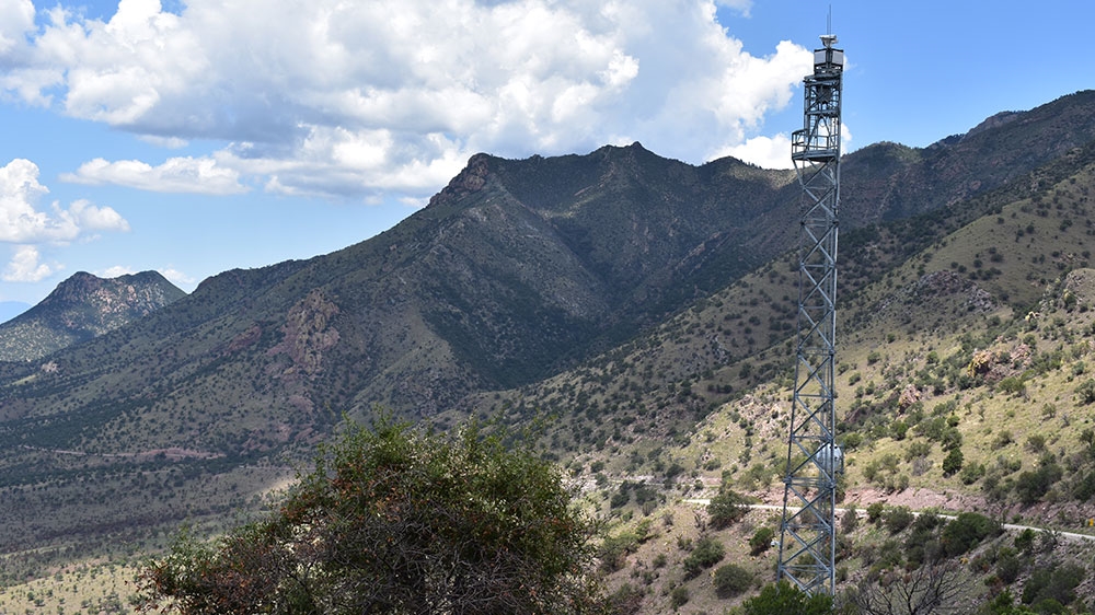
“I think we in the Park Service, we said could tolerate a surveillance tower or the use of drones or other technological investments in border security over building an impenetrable wall because we knew the wall would have much more significant environmental impacts than a surveillance tower,” Jarvis told Al Jazeera.
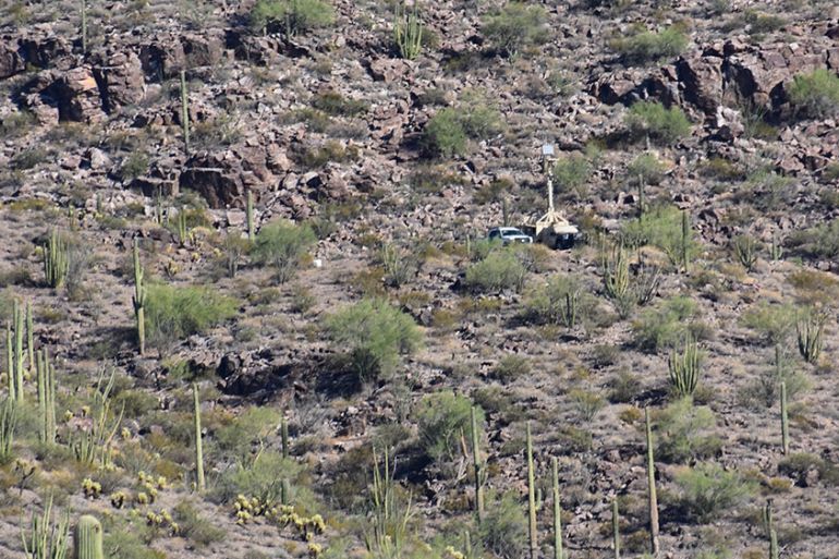
Visit any federally managed public land along the border now, however, and it is clear that more than surveillance towers are in operation. On a trip along the entire length of the border, from the Tijuana River National Estuarine Research Reserve in San Diego to the Lower Rio Grande National Wildlife Refuge more than 3,100km (1,926 miles) later, outside Brownsville, Texas, Al Jazeera witnessed a wide range of surveillance equipment, including drones, aerostats, ground sensors, automated license-plate readers, thermal imaging cameras, bullet cameras, dome cameras, mobile surveillance towers and poles, and other devices – all meant to help authorities keep a watchful eye on anyone trying to cross the border irregularly. The presence of these devices was confirmed by federal acquisition reports and budget items, field staff, and experts confirming photographic evidence.
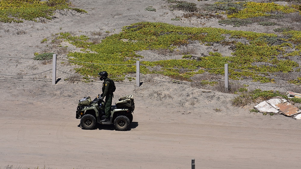
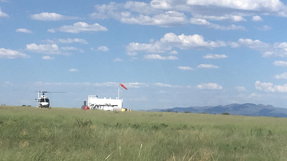
Moreover, within and surrounding federally-protected areas loomed an intimidating CBP presence, including thousands of vehicles bearing the CBP Border Patrol logo, helicopter landing zones within wildlife refuges, officers on all-terrain vehicles or riding horseback, and K-9 units.
Border Patrol has also established dedicated outposts to monitor their many surveillance cameras in national parks, wildlife reserves and other federally managed protected areas along the border.
CBP did not respond to Al Jazeera’s request for comment. In its stated mission, it says it operates to “safeguard America’s borders”.
It's a whole zone of surveillance. Everywhere, there are guys with guns and helicopters.
Louise Misztal, conservation director of the Sky Island Alliance, which is working on cross-border resource protection, said the buildup of surveillance at the border is creating a “no-man’s land where you as a member of the public cannot use your public land” without the presence of CBP.
“It’s a whole zone of surveillance. Everywhere, there are guys with guns and helicopters. My team has been buzzed by Border Patrol,” she told Al Jazeera, describing a method where aircraft fly lower than standard procedure as a means of intimidation. “You can run into Border Patrol, be harassed, many miles from the actual border.”
‘Like a warzone in so many ways’
The exact number of devices and their purpose is kept a closely guarded secret, even from those within the land management agencies themselves. While serving as a Wilderness Fellow at two border parks that often feature prominently in border debates – Big Bend National Park in Texas in 2015 and Organ Pipe National Monument in Arizona in 2017 – Laiken Jordahl was tasked with inventorying threats to wilderness, particularly as they related to cross-border issues. Jordahl, who now works with the Center for Biological Diversity, quickly ran into obstacles in his research.
“Part of my job was talking to Border Patrol and trying to get a sense of all the things that they have scattered about in the wilderness. And it was clear that…they felt, you know, everything was a security issue and they couldn’t even give us ballpark figures for any of the equipment that they had there,” Jordahl told Al Jazeera.
“But I know anecdotally that they have cameras and sensors and trail monitors and radio towers well into the thousands. They also have mobile command units that are like big trucks that have all sorts of different infrared cameras. It’s top-grade military-style technology. They even have like a military-style forward operating base in Organ Pipe,” Jordahl added, referring to Arizona’s Organ Pipe Cactus National Monument and UNESCO biosphere.
“It’s just like a warzone in so many ways,” Jordahl said.
It is perhaps no coincidence that many of the CBP sector offices are within sightline of some of the largest natural areas on the border. The Del Rio, Texas, sector, for example, is mere kilometres from the vast Amistad National Recreation Area, where CBP has used mobile surveillance vehicles, integrated fixed towers, and remote video surveillance systems, among other technologies. In the Big Bend sector, near Big Bend National Park, CBP has used remote video surveillance systems and mobile surveillance units. These federally managed areas often offer fewer restrictions than state and municipal patrols, and are subjected to fewer state and local politics about border surveillance activities.
“The reason that these areas are federal lands is because they are so ecologically important. And that same fact is what allows them to be able to have walls ramped through them quickly,” Jordahl said.
‘Never pee outside’
Even when part of a shared ecosystem, these parks can vary greatly in terms of frontcountry or backcountry experiences. Heavily trafficked national parks, for instance, are often more accessible than remote wilderness reserves. Because of this, the methods of patrols also can vary greatly, which can have profound effects on the wilderness, and wildlife, in each area.
“At Big Bend (National Park), you still have CBP rangers patrolling on horseback, which is incredible. That is the least damaging and intrusive means of patrolling,” Jordahl said. “Whereas at Organ Pipe (National Monument), you’ll never see a Border Patrol agent get out of their vehicle. I mean, they do all of their fieldwork within the comfort of their air-conditioned vehicles. And that has pushed all the [foot] traffic up into the AJO mountains and other high areas of Organ Pipe. And that means also that’s where most of the biological diversity is encountered in Organ Pipe and you’re seeing impacts on [the] bighorn sheep population there.”
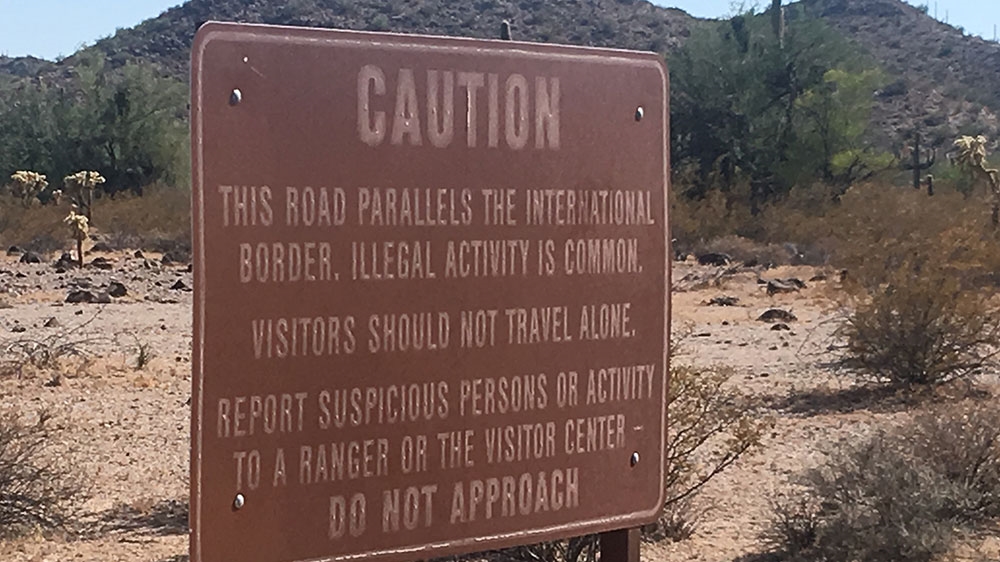
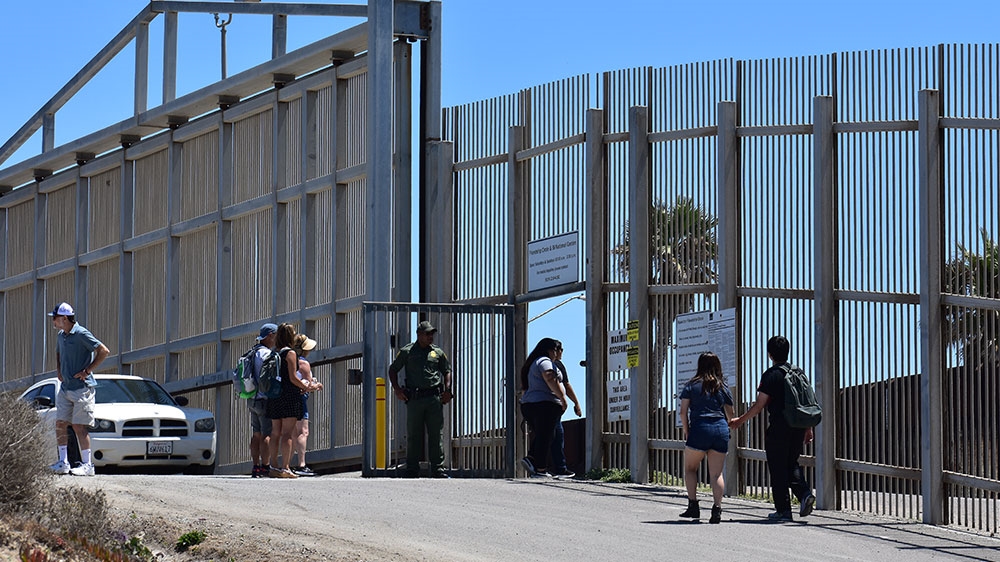
For potential visitors, reaching public lands along the southern border, even without crossing the border itself, often requires passing through multiple immigration checkpoints, often large, fixed, structures spanning the road. Fully manned by CBP, these stops can vary dramatically, from a wave-through to a vehicle inspection, identification check and questioning.
The effect is chilling for staff and guests alike. On one night in August, a woman enquiring about camping options in Organ Pipe was told that National Guard members were conducting training exercises in the park overnight using night-vision goggles. A solo camper, she opted instead for a hotel.
A biology intern said she was told on her first day working in the vast San Bernardino National Wildlife Refuge in Arizona, “Never pee outside. Even if you can’t see them, you’re being watched constantly by Border Patrol.” Several staff members explained that at various parks, they’re introduced to local Border Patrol officers on their first day of work to avoid any potential issues.
This Border Patrol presence is in addition to the law enforcement officers that public land management agencies have within their own ranks, colloquially known as “LE’s” within the community. The Department of the Interior, which oversees the National Park Service, the Bureau of Land Management, the US Fish and Wildlife Service, and other federal land management agencies (but not the US Forest Service), boasts: “The Department’s Law Enforcement Program has the third largest contingent of federal law enforcement officers in the Executive Branch. Depending on the season, approximately 3,500-4,000 law enforcement officers, rangers, and other employees patrol vast acres of public lands, national parks, wildlife refuges, and Indian communities and protect natural, cultural, and heritage resources from illegal activities.”
In addition to cooperating with CBP, these land management federal law enforcement officers also often cooperate with local police forces, in what the Department of Interior identifies as a “whole government approach”. Such was the case when the US Fish and Wildlife Service used a mobile app from the Automated Regional Justice Information System to run more than 200 facial recognition requests off the San Diego mugshot database between 2016 and 2018. The Tijuana Estuary is in San Diego county, and the US Fish and Wildlife Service is one of its managing agencies.
The Department of the Interior also reported in 2018 that it owned 531 drones and had 359 operators distributed across 42 states and territories. Like much of the technology within public lands, surveillance can serve a variety of purposes, including wildlife tracking, wildfire prevention, volcanic eruption monitoring and tracking vandals, poachers and traffickers. But, once the technology is in place, this “whole government” approach can also include data-sharing.
“Agencies have these privacy impact assessments that they have to write, saying what they’re using the technology for, but they don’t actually really have a lot of enforcement to prevent them from doing anything more,” said Dave Maas, an investigative researcher at the San Francisco-based Electronic Frontier Foundation.
Laws waived to build wall
From one end to the other, the southern border of the US has long been protected as critical habitat deserving of protection. However, under the administration of President Donald Trump concrete walls, long abandoned as unnecessary and destructive, are gaining a new life, even after a digital bulwark has rendered them obsolete, the fortifications of a bygone, analogue era.
Trump campaigned in 2016 on a promise to build a wall along the US-Mexico border. He has run into funding challenges and other roadblocks since taking office but that has not prevented his administration from bulldozing through public lands and destroying ancient habitat.
“The Department of Homeland Security has waived every single relevant environmental law to ram this project through protected, spectacular landscapes. Every day we see more cactuses ploughed over, sacred sites bulldozed, and wilderness lands destroyed,” Jordahl said.
“In the Rio Grande Valley, we’re seeing walls go up through the Rio Grande Valley National Wildlife Refuge, which, yeah, that’s like the best remaining habitat in all of south Texas. And same thing with Santa Ana (National Wildlife Refuge)” Jordahl told Al Jazeera. “I mean, we’ve heard that was the first place that Border Patrol wanted to build a wall. That’s, like, the most biologically diverse, the most important for the local economy or for birding for tourists.”
The Trump administration has used part of the 2005 Real ID Act that allows DHS to waive compliance with federal laws in an effort to speed up construction of border barriers.
The Trump administration has so far waived dozens of acts, including the Endangered Species Act.

Last month, Border Patrol said contractors began using explosives on part of the Organ Pipe Cactus National Monument in Arizona to make way for wall construction. The move has angered environmental groups and the Tohono O’odham Nation, who says Indigenous burial sites are being blown up.
CBP said in a statement that it found “no biological, cultural or historical sites” within the project area, a claim Indigenous and environmental groups immediately dismissed.
“DHS is sucking tens of millions of gallons of groundwater out of the aquifer to mix concrete for the wall. Each drop of water they extract is being stolen from future generations and threatening endangered animals at Organ Pipe, like Quitobaquito pupfish and Sonoyta mud turtles, that are found nowhere else on the planet,” Jordahl said.
We have drones. We have quads. We have horses. We have helicopters. We have four-by-fours. We have sensors. Why do we need a wall?
For those who got into federal land management to protect the environment and its wildlife inhabitants, these changes can be a bit too much to bear.
Ben Lomeli, a former Bureau of Land Management employee in a border park who took early retirement last year, watched in consternation as fences, then walls, were erected in fragile habitat, and still ponders the need.
“We have drones. We have quads. We have horses. We have helicopters. We have four-by-fours. We have sensors,” Lomeli told Al Jazeera.
“Why do we need a wall? Normally you see these, like, photos and videos of the wall, and they just have the Normandy barriers and such. Then they ask, ‘well, anybody could walk through here, right?'” he said.
“Yeah, but you didn’t turn the camera around to the other side of the road where there are three border patrol units sitting there,” he added. “It’s biased information, to put it mildly.”
*Molly McCluskey is a former National Park Service interpretation ranger.
This reporting was made possible by a fellowship with the International Center for Journalists and the Border Center for Journalists and Bloggers.
Source: Al Jazeera