India dam disaster: The trigger event and warnings for the future
Questions are being asked about how the disaster happened, and what, if anything, can be done to prevent similar incidents in future.
Published On 10 Feb 2021
“We are the last generation that can prevent irreparable damage to our planet,” were the opening remarks of the United Nations General Assembly’s former President María Fernanda Espinosa Garcés at the 2019 Climate and Sustainable Development meeting.
Citing the conclusion of an Intergovernmental Panel on Climate Change (IPCC) report, she added: “Eleven years is all we have ahead of us to change our direction.”
Keep reading
list of 4 itemsWhy glaciers burst and send floods downstream
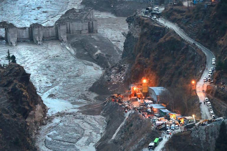
In Pictures: The deadly glacier collapse in Indian Himalayas
‘We thought this is our end’: India villagers on glacier disaster
The stark proclamation aimed to stir member states into taking preventative action, to steer humanity away from irreversible environmental destruction. Such actions are gradually being implemented and exercised around the world, but irreparable and unavoidable damage are not two mutually exclusive scenarios.
In India, as rescue efforts continue in the northern state of Uttarakhand following Sunday’s devastating glacial event and dam collapse, questions are being asked about how this disaster happened, and what, if anything, can be done to prevent similar incidents in the future.
It is indisputable that the demise of the Himalayan glaciers has rapidly accelerated over the past four decades, contributing to an increased prevalence of landslides and avalanches. As coral bleaching and desertification are symptoms of changing environmental conditions, so too is the disintegration of a glacier’s integrity.

Global warming is forcing dramatic structural shifts upon the world’s ice caps and permafrost, and every year, those alterations are becoming more apparent and violent in effect.
An exact timeline of the specific events leading up to the disaster in Uttarakhand has yet to be firmly agreed upon – experts from numerous earth science disciplines are still on the ground assessing various mountain sites – but remote imaging specialists pooling the latest data together over Twitter have been piecing together a working theory.
Possible triggers
Dan Shugar, a geomorphologist from the University of Calgary, studies rapid geologic change in high altitude environments. He and several others have employed satellite photographs taken immediately before and after the event to determine that a rock-avalanche is a strong contender as the initial trigger event.
WOW – @planetlabs has updated image of #UttarakhandDisaster. Looks like massive dust deposition over much of W side of the valley and the trigger appears to be the landslide scar that I discovered a few minutes ago. So NOT a typical GLOF. @davepetley @BhambriRakesh @irfansalroo https://t.co/kXF2fNp2ui pic.twitter.com/m04DXLJnv1
— Dr Dan Shugar (@WaterSHEDLab) February 7, 2021
Speaking from Canada, Shugar said: “What I initially interpreted from the images looks like some form of landslide from high up on a ridge. It was likely a combination of glacier ice and bedrock from a relatively small, but very steep glacier up high.
“This tongue of ice collapsed taking the bedrock with it. Much of the ice would have melted on impact as the heat generated during these impacts is tremendous, possibly melting even more ice on the ground around the valley bottom.
“What we still don’t really know for sure is where all the water in the videos came from. I don’t see any evidence of a glacial lake that burst – an event not uncommon in the Himalayas and quite often when you have a flash flood like this, a glacial lake outburst flood (GLOF) is the culprit, but in this case, I don’t think that occurred.
“As of yet we can’t definitely link the event to climate change, but generally speaking, as the climate is warming we’re seeing the thawing of alpine permafrost and the thinning and retreat of glaciers in much of the world. A combination of those factors is resulting in an evolving hazards landscape.”
What caused the initial breakaway remains unclear and may not be known for some time, but in January a Chinese research team concluded glacier-related landslides in the Himalayas have increased in both frequency and size throughout the past decade. The same team also warned that if climate warming continues, the likelihood of large landslides will also increase.
But as Shugar and other geoscientists have noted, the sheer volume of water displaced during the event has also raised more questions than answers, and drawn attention to the region’s growing population of glacial ponds and lakes.

Glacial ponds
Backdated satellite photographs of the glaciers straddling Nanda Devi, India’s second-highest mountain, close to where the Rishi Ganga Hydroelectric Project is located, show the changes in snow and ice cover over the past five years.
During the winter months from 2016 to 2019, the region received a gradual increase in the surface area of cover, with a markedly significant increase through February 2020.
By mid-summer 2020 the seasonal cover had melted, leaving behind only perennial snow and glacier ice. Most of the summer melt will have returned into the water cycle, but the bumper seasonal coverage also suggests a disproportionate amount of water will have found its way into the crevasses of Nanda Devi’s glaciers.
Part of the process of a glacier’s retreat leads to the creation of glacial ponds – bodies of melt water that form on top of, or within, a glacier.
As these ponds grow in volume – some are known to hold millions of cubic litres of water – so does the pressure they impose on the surrounding barrier.
When that pressure reaches breaking point, even a minor landslide or shift in the ice is enough to send millions of tonnes of water and debris cascading downslope.

Rachel Carr, a glaciologist at Newcastle University’s Department of Geography, has researched the evolution of glacial ponds in the Himalayas. She views them as a significant hazard, and notes rising temperatures also impose a damaging feedback loop upon glaciated regions.
“We see them growing and the ponds expanding very rapidly,” she says. “We can see from remote sensing data [Satellite images] they grow and coalesce together into lakes which can be very dangerous. And as time goes on there’s going to be more of them with more and more water.
“Normally ponds would be near the terminus (a glacier’s foot) where it’s warmer and the water can drain away. But over time as the profile of the glacier flattens, it becomes less steep and stagnates.
“Because of this there’s fewer crevasses so it’s not easy for water to drain off, which results in ponds forming over more parts of the glacier.
“The ponds themselves also encourage the melting of the glacier through positive feedback since they’re warmer than the ice and are filled with sediment and debris that absorb heat. This could explain why the glaciers are losing mass so quickly.”
Early warning systems
A key recommendation from Carr’s research is the call for glacial ponds to be mapped and monitored for future risk assessment.
“We have to consider what’s living downstream from the glaciers,” she adds. “On one hand we have climate change making more water upstream, but downstream we’re also getting population and infrastructure growth.
“In terms of assessing hazards and early warning systems, it needs to be taken very seriously. These events are likely to happen more frequently in the future. The key question is: where will they occur and when?”
Her concerns over the growing human footprint in environmentally sensitive areas are also backed by climate change expert Chandra Bhushan of the International Forum for Environment, Sustainability & Technology (iFOREST).
Bhushan says construction projects such as the Rishi Ganga hydroelectric project are being developed in remote areas regardless of the landscape’s structural integrity.
“There’s other elements alongside climate change such as human intervention in the form of the construction of hydropower stations. These can make an entire area prone to these kinds of disasters,” he told Al Jazeera.
“This is an extremely fragile ecosystem. The Himalayas itself is a very young mountain system and is prone to landslides. On top of that, you now have climate change melting the glacial ice.
“There is a growing debate in India over the construction of such power plants, and we’re talking about smaller hydropower plants. The plant in the way of this disaster was a less than 15mW power station, which raises the question: Should be we compromising the integrity of the Himalayas for such a small project?”

The irreparable vs the unavoidable
Warnings over the instability of the Nanda Devi region are not new. Its glaciers are under extensive scrutiny and have been the subject of detailed academic research for more than three decades. In past years it has seen several fatal avalanches – the most recent and high-profile incident in May 2019.
That same year a resident from Chamoli, a district in Uttarakhand, filed a petition at the state’s High Court charging that a local power station was being built using environmentally unsafe methods involving explosives, with the contractors also dumping large quantities of rock fragments and waste into a river.
In 2020 one of the authors behind a 16-year study analysing nearly 40 years of ground surveys and regional satellite data, said the changes in the glaciated areas had imposed “major effects on various aspects of the life of people living in about 47 villages in the buffer zone of the Nanda Devi Biosphere Reserve”.
To return to the questions posed earlier, the answers to both are unlikely to ease the minds of the millions of people who live across the Himalayas and the hundreds of thousands who choose to make yearly pilgrimages through its mountain paths.
Understanding the cause appears relatively simple: The Himalayas is a region where the encroaching effects of climate change are being compounded by humans physically altering an already unstable and shifting landscape.
And what can be done, it anything at all? At this late stage with some degree of climate warming being inevitable, mitigation of the feared irreparable is a far more realistic approach than attempts to prevent the now unavoidable.
Source: Al Jazeera