Region prone to earthquakes
Ravaged by an earthquake claiming thousands of lives and totally destroying the ancient city of Bam, Iran is located in a tremor-prone region, with major calamities dating back to ancient Persia.

The worst disaster of modern times claiming 40,000 lives occurred in June 1990 in the provinces of Ghilan and Zandjan in northern Iran.
Measuring 7.3 on the Richter scale, it devastated an area of 2,100 square kilometres containing 27 towns and 1871 villages in the space of seconds.
Other countries in the region such as Turkey, Syria, Armenia and Afghanistan have also been visited by similar catastrophes.
Indian pressure
A major cause of the phenomenon is to be found in the depths of the ocean, where traces of movement by the Indian subcontinent northwards have been detected.
Seventy million years ago, India was nearly 7000km from the future Eurasian landmass.
Gradual tectonic plate shifts slowly brought it closer till it eventually made contact with the continent to the north.
India has continued pushing at Eurasia. The pressure has eased from 10cm a year during the 30 million years before the collision, to five cm today. Nevertheless, such a progression can cause seriously violent shocks and tremors at any time.
Regional fault lines
The Middle East is crisscrossed by several major fault lines which produce earthquake activity.
Turkey, which has suffered several major earthquakes in recent years, has two such faults: one running along the north of the country, another through the south and east.
Following is a list of some of the worst quakes over the past four decades.
- 22 June, 2002: Qazvin and Hamedan provinces in western Iran: 235 dead, 1300 injured (magnitude 6.3).
- 10 May, 1997: Birjand, eastern Iran: 1613 dead, 3712
injured (magnitude 7.1).
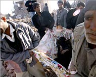
Residents of Bam carry the body of
a victim after the latest earthquake - 28 Feb, 1997: Ardbil region in northwestern Iran: 965 dead and 2,600 injured, according to an official toll. Aid agencies put the toll at 1,100 dead (magnitude 5.5).
- 21 June, 1990: Northwestern Iran: About 37,000 killed and more than 100,000 injured in Ghilan and Zandjan provinces in the deadliest and most powerful quake to hit the country, with a magnitude of 7.7. The quake devastated 27 towns and about 1870 villages.
- 11 June, 1981: Kerman province in southeastern Iran: 1028 dead and 950 injured, with the city of Golbaf hit the hardest. On 28 July, another 1300 were killed in a second quake in the same region.
- 16 Sept, 1978: Eastern Iran: 25,000 killed. The city of
Tabass is destroyed, with 15,000 dead there alone.
- 10 April, 1972: Ghir region in the southern Iranian province of Fars: 5044 killed and 1336 severely injured. Forty-five villages destroyed.
- 31 Aug, 1968: Khorasan province in northeastern Iran: About 10,000 dead.
- 1 Sept, 1962: Qazvin, west of Tehran: 12,000 killed and 200 villages destroyed.
<