No break for Asia
Strong storms have left many regions flooded while another typhoon is brewing
Published On 31 Jul 2011
 |
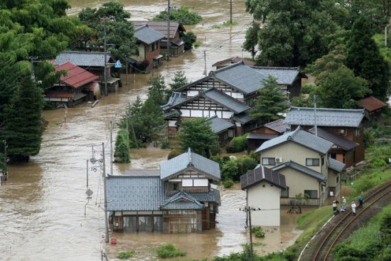
| An aerial view shows a flooded residential area in northern Japan July 30, 2011 [REUTERS] |
Last week was devastating and deadly for many parts of Asia as weather systems left their mark with flooding and landslides.
The week began with Typhoon Nock-Ten moving across the Philippines leaving more than 50 people dead and over two dozen missing. The storm then moved across the South China Sea making a second landfall on Hainan Island and then a third landfall in Vietnam.
Keep reading
list of 4 itemsTurtles swimming to extinction in Malaysia as male hatchlings feel heat
Could shipping containers be the answer to Ghana’s housing crisis?
Thousands protest against over-tourism in Spain’s Canary Islands
The effects of Nock-Ten will still be a factor over the next few days as the remnants move west towards southern Myanmar. After weeks of monsoonal showers, the ground across the region is saturated, only worsening the potential flooding. Over 200 millimeters of additional rain is likely.
Into northeast Asia, a separate system brought strong storms and flooding with it as well. What began as a cold front in Mongolia continued to move eastward, strengthening and picking up more moisture. Beijing saw the night skies light up with a spectacular lightning show while around the city streets soon flooded from the quickly moving thunderstorms.
Across the Yellow Sea, the Korean Peninsula saw what is being considered the “worst flooding in decades”. North Korea is now suffering as the flood waters have inundated rice fields and destroyed roads, houses and public building. In South Korea landslides and flash flooding are being blamed for over 70 dead and missing. 11,000 people have been left homeless in the wake of the storm.
Japan, a country that this year alone has already seen devastation from an earthquake, tsunami and a previous typhoon’s heavy rain, again saw floodwater by week’s end ravage the prefecture of Niigata.
Most of Asia will now have several days of better weather to allow some of the waters to recede. Eyes are now turning to the western Pacific where Super Typhoon Muifa is strengthening. Still located over 1000 kilometers southeast of Okinawa, Japan, Muifa’s forecast track is to move north then northwest.
It is not until midweek before the storm is expected to interact with the Japan’s Ryuku Islands. After that the long term forecast is unclear. But a landfall could be seen anywhere from eastern China to southern Japan later in the week. Watching this storm’s track will be key as many areas will still be saturated and unable to handle the potential rainfall from this next system.
Source: Al Jazeera