
Could there be relief for Sudan?
A scientist has discovered an ‘ancient mega-lake’ that could provide water.
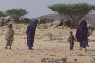 |
| Food and water is often in short supply in Sudan |
Security and safety is the primary concern for the millions of refugees fleeing the brutal fighting in Darfur. But beyond the conflict is the long-term concern for food and water – which is often in short supply.
One Egyptian scientist – a veteran of NASA – believes he has found an answer in the form of what is being called an “ancient mega-lake”. If successfully drilled this underground water supply may provide some relief for those suffering in Sudan.
But even before engineers can begin drilling the more than 100 metres that will be required in order to reach this water supply, many scientists are expressing skepticism about the project which may block it’s progress.
On Wednesday’s Riz Khan we speak with the scientist responsible for the discovery, Dr. Farouk El-Baz who is the founder and director of Boston University’s Remote Sensing Center. We will ask Dr. El-Baz if water exists in Darfur and what it may mean.
Watch this episode of Riz Khan here:
Watch this episode of Riz Khan Street Talk here:
https://www.youtube.com/watch?v=PC_iMmC_Dl4
This episode of Riz Khan aired on 01 August 2007
Don’t miss Riz Khan live at 19:00GMT, when you can call with your questions and comments. Riz Khan is also shown every day at 00:00GMT, 05:00GMT, and 09:30GMT.
| Your comments: |
Dear Riz, I have been a great fan off your prog and after yesterdays prog on the under water lake in Sudan I request you to look into the following geographical event that has perplexed a lot of pilots in this region (I am a Helicopter pilot flying for UN Mission in Sudan) I had floated this question on yahoo but did not get adequate response. This is about Very long, Straight, Unidentified tracks in Sudan especially between Kadugli and Abyei. I have loaded the photos as a blog at http://blog.360.yahoo.com/blog-4b11gigwa… Also I have been told that they are discernable on Google Earth Plus (in normal Google Earth I could zoom in only till 10thou feet) First photograph is of a point 10deg 39.61min North, 029deg 17.81min East These photos have been taken on a track of 218 deg from Kadugali town (Airfield ICAO Code HSLI) at various intervals from an AMSL altitude of 5500 feet. The second set is on the same track at a distance of 54 nautical miles at coordinates of 10.2593 / 02906.78. Mind you – these tracks r rampant all over southern Sudan & run for tens of miles in a ruler straight line. So Can you please refer this question to Dr Al-Baz of Boston Univ remote sensing centre who may be able to throw some light on it. Regards,
Asheesh – Sudan
To contact us click on ‘Send your feedback’ at the top of the page
Watch Al Jazeera English programmes on YouTube
Join our debates on the Your Views section of the site