Northern Namibia braced for worst flood in memory
This year’s wet season brings significant flooding to the most densely populated area of the country.
Published On 17 Mar 2017
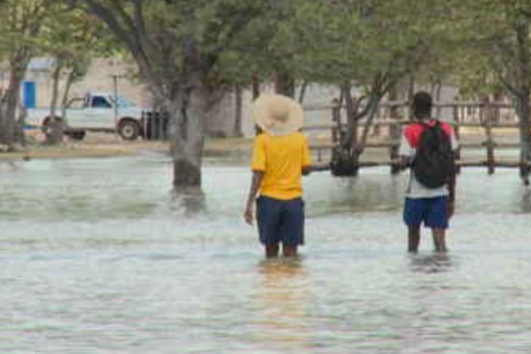
Flooding in Namibia’s Cuvelai-Etosha catchment area has reached alarming levels in recent weeks, with residents being warned to take the necessary precautions in expectation of the worst possible floods experienced in the region in living memory.
This is according to the Ministry of Agriculture, Water and Forestry; the disaster risk-management division in the prime minister’s office; and the Namibia meteorological services.
Keep reading
list of 4 itemsAsia bears biggest climate-change brunt amid extreme weather: WMO
Photos: Highest-level rainstorm warning issued in south China’s Guangdong
Europe endured record number of ‘extreme heat stress’ days in 2023
|
|
In a joint statement, the authorities warned that the magnitude of flooding expected in the northern central regions is likely to surpass that of 2011, which saw the highest level of flooding in Namibia’s recent history.
“The 2017 floods are predicted to become even higher if good rains continue, as they are both in the headwaters of the Cuvelai catchments in southern Angola and in the northern border areas of Namibia within these catchments,” the statement said.
The situation is predicted to be made worse by the opening of the sluice gates of the Gove Dam. Water from the dam is expected to flood the Kunene River, which in turn will flood parts of southern Angola and northern Namibia.
Erratic rainfall
Efundja, the annual seasonal flooding of the northern parts of the country, often causes not only damage to infrastructure but also loss of life.
The rains that cause these floods fall in Angola, then flow into Namibia’s Cuvelai basin and end up filling the flood plains there.
The basin is characterised by an interconnected system of shallow water courses, called oshanas, which are the “life-support system” for the most densely populated area in the country. They are easily prone to flooding through excessive rain or controlled release from dams.
Water levels in the oshanas in the Omusati region have been rising since last week, an indication that more water from Angola has been flowing into the country.
Namibia is considered to be one of the most vulnerable countries to the effects of climate change in sub-Saharan Africa. Dry land, a hot and dry climate and erratic rainfall patterns, have traditionally exposed the country to recurrent droughts and wild fires.
In Namibia’s interior, surface water is available only in the summer months when rivers are in flood after exceptional rainfalls. Luckily, boreholes can be used in about 80 percent of the country.
Source: Al Jazeera, News Agencies