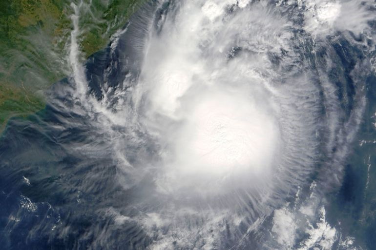
Severe storms threaten flooding in eastern India
The Andra Pradesh area is braced for some level of flooding as remains of Tropical Cyclone Kyant close in.
Published On 28 Oct 2016
Much of eastern India is set for a very wet weekend as the remnants of Tropical Cyclone Kyant make landfall.
The coastal parts of Andra Pradesh will see the worst of the rains and much of the region is braced for some level of flooding.
Keep reading
list of 4 itemsAsia bears biggest climate-change brunt amid extreme weather: WMO
Photos: Highest-level rainstorm warning issued in south China’s Guangdong
Europe endured record number of ‘extreme heat stress’ days in 2023
The system developed in the Bay of Bengal on October 25, and it is the second tropical cyclone to form in these waters this year after the Tropical Cyclone Roanu in May.
At one stage, this small, well-organised tropical cyclone had violent storms dropping rain at a rate of 215mm per hour, according to NASA’s Global Precipitation Measurement core observatory satellite.
The system has weakened over the past couple of days and a final warning has now been issued in terms of the winds.
Those winds are still squally but have now dipped below 45km/h. They will continue to lose strength over the weekend.
Moderate to rough seas are expected off the coast of Andra Pradesh and fishermen have been advised to take care when venturing out to sea.
The remnants of Kyant currently lie around 250km to the southwest of Visakhapatnam, close enough for the city to register 72mm of rain on Thursday.
What is now a deep area of low pressure will continue tracking west at around 10km/h, threatening flooding along a good part of coastal Andra Pradesh.
The associated rain will gradually fizzle out over Kerala by the start of next week as the northeasterly winds officially set in.
The Indian Meteorological Department has declared conditions to be favourable over southern India around October 30, with the withdrawal of the southwesterly monsoon from the entire country taking place on October 28.
Source: Al Jazeera