Winter warmth breaks Australian records
Tropical air has brought record rain to Queensland, and now brings some outstandingly high night-time temperatures.
Published On 20 Jul 2016
After an incursion of tropical air brought record, and welcome, rain to Australia’s Queensland, it now brings fog and warmth further south.
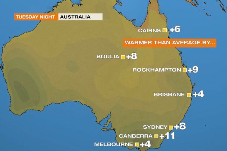
Canberra, Australia’s capital, felt the warmest July day in 41 years on Tuesday at 18.8C. This was followed by the warmest July night since records began in 1939. The minimum was 11.1C on Tuesday night, beating the previous record of 10.5C set in 1975.
Keep reading
list of 4 itemsAfter the Hurricane
World’s coral reefs face global bleaching crisis
Why is Germany maintaining economic ties with China?
In fact, this figure almost matched the average daytime high in July, of 11.4C. The average minimum for the month of July is 0C and the lowest temperature so far this month has been -5.2C.
Sydney’s temperature fell to only 16.5C, the warmest July night in 74 years. Similarly, most of the Central Tablelands, west of Sydney and including the Blue Mountains, had their warmest recorded July night, with, Katoomba and Bathurst close to 12C.
This warmth in mid-winter is because of cloud cover. There was also extensive fog, which came as a result of this tropical air cooling down. The fog alone in southern Queensland disrupted morning traffic.
https://twitter.com/SarahMotherwell/status/755181193214078976
Leonie Vandeven, the Brisbane Airport media manager, said five planes had been diverted to other airports, including international flights from New Zealand and the United States. “We only have a handful of fog events each year but this one has certainly left her mark.”
This type of weather will not last much longer. Colder air brought in across the Great Australian Bight will sweep all evidence of tropical air away before the weekend.
Source: Al Jazeera